
From Lander to Sheridan, Laramie to Evanston and almost everywhere in between, the 2025-26 winter officially goes down as the warmest winter since recordkeeping began in the 19th century.
The December-through-February period — known as the meteorological winter — set new high marks for average low temperature, average temperature overall and average high temperatures. Record heat across the season was recorded where climate stations were relatively new. And thermometers also climbed higher than ever before, where daily highs and lows have been recorded for 135 years, which is the case in Lander.
Lander’s three-month average maximum temperature was 47.7 degrees; its average overall was 34.6 degrees and the average minimum was 21.6 degrees. Each set the new all-time high mark, surpassing the historically warm winter of 1933-’34, according to National Weather Service Meteorologist Adam Dziewaltowski.
“That was one of the worst years for the Dust Bowl,” Dziewaltowski told WyoFile. “So it’s not good company.”
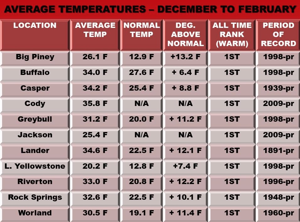
All other climate stations monitored by the National Weather Service’s Riverton Office set their all-time warmest winter records, including in Big Piney, Buffalo, Casper, Cody, Greybull, Jackson, Lake Yellowstone, Riverton and Rock Springs. The office posted about it on Facebook, sharing the official numbers as well as the departures from average.
Several other National Weather Service offices monitor other portions of Wyoming. Querying data from those in Cheyenne, Billings, Salt Lake City and Rapid City, WyoFile learned of only one climate station that did not register its warmest winter on record. That was in Newcastle, which had its second-warmest winter on record.
“Obviously, there’s going to be some place or some elevation where it’s not going to be the warmest winter,” Wyoming State Climatologist Tony Bergantino said. “But I think you can say, generally speaking, around the state, it’s been the warmest.”
Bergantino is awaiting a batch of Wyoming climate station data to go through quality control. By around March 7, he said, there should be more finalized figures to describe the anomalous winter.
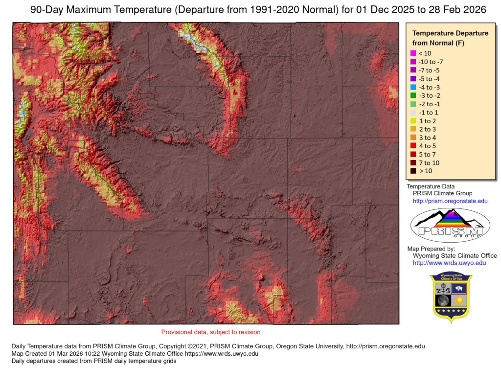
Lower-elevation areas in particular were unseasonably warm. Most in Wyoming were more than 10 degrees above average. Mountainous areas, especially in the northwest, weren’t as divergently hot — and the high-elevation snowpack in a handful of river basins is even near average.
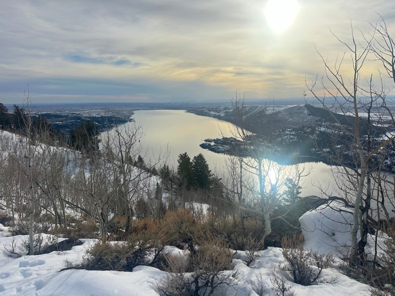
But down low, it was a completely different story. Lander, for example, sits in the Wind River Basin, where the snowpack on Monday was 103% of the long-term median. But at the climate station, located at the 5,589-foot-elevation Hunt Field airport, just 8.2 inches of snowfall was recorded over the three winter months — the least ever, and just 16% of the average in-town snowfall of 52.9 inches, Dziewaltowski said.
Sometimes thermometers toppled previous records by significant margins.
Over the 90 days of winter in Sheridan, temperatures breached 60 degrees on 20 different days and 50 degrees on 44 days.
“So practically half of the meteorological winter had highs over 50 degrees Fahrenheit,” said William McKeown-Robbie, a Weather Service meteorologist out of the Billings office.
Lander also had its share of especially unseasonably warm days. December hit a new monthly record high temperature. And there were two days in December, three days in January and one day in February that cracked the top 10 all-time highs for the month.

Christmas Eve in Lander reached 65 degrees, beating the previous all-time high by a whopping 10 degrees in a dataset that traces back to 1891.
“Very strong” high-pressure systems consistently parked south of Wyoming near the Four Corners region partly explains the record-setting season that’s now passed by.
“That kept anything coming down from Canada and the Arctic east of us,” Dziewaltowski said.
“I don’t believe in climate change!” Your opinion about climate change doesn’t matter. What matters is does your INSURANCE company believe in climate change? Re-insurance companies, i.e. the global giants who insure YOUR insurance company – think Lloyd’s of London, Swiss Re, etc., have studied climate change for almost a century. They use cold hard facts generated by long-term scientific studies, not political talking points, to set insurance rates for American companies which pass cost increases on to you. These international behemoths don’t intend to suffer financial losses due to weather related events, and the increasing cost of insurance policies reflects their protracted knowledge. Some people won’t understand this until the day they can’t obtain property insurance or afford the premium.
Chad, the jet stream behaving abnormally is a direct – and predicted – symptom of manmade climate change. As polar ice melts, it causes temperature anomalies disrupting and altering the gulf stream. Also, as the planet has warmed, it has caused the ocean to absorb more heat. These changes (among others) disrupt global airflow that is heavily impacted by worldwide ocean temperatures. Taking your question as an honest request for an explanation, here’s the best metaphor I can think of: if you’ve ever lived in a house with double hung windows, you probably know that opening the bottom window and cracking the top during cooler weather is a good way to encourage cooling airflow in your house. Warm air rises, escaping through the top, which in turn draws the cooler air inside. If however the outside temperature increases, or you close one part of the window, that flow stops or if the change is drastic enough, reverses. Now think of warmer and cooler portions of the ocean operating like that double hung window. Industrial production of greenhouse gasses has effectively closed the top window AND heated up the outside.
Donald Day is eating crow on his long term winter projection from late last fall. ” colder n above avg snow” Nope
I’m gonna side with the career researchers over the guy who looked directly into the sun during an eclipse on this one.
I wonder how the winds from this winter line up with the winds from the dust bowl. Was the warm dust bowl winter just as windy as this one?
We are witnessing climate change in shockingly real time. Yes, we’ve had warm winters in the past but nothing this extreme; nothing this consistent as we’ve seen over the last 20 years; and not such huge swings in such a short amount of time. This is irrefutably tied to the burning of coal, oil, and natural gas. I’m disappointed this wasn’t noted in the article.
It will be interesting to see how this warm winter start-up plays out for wildlife and livestock over the rest of the year.
Has anyone in Cheyenne ever seen leaves on trees in the first week of March? My elms will get leaves within the next week. 2 months ahead of normal.
Yes, chad Humans also had an impact on climate back then too.You can go all the way back to the black plague which we now know helped cause the little ice age. And you can directly tie the temperature to the amount of people on the planet. by the mid eighteen hundreds, we were burning lots of coal and oil. We were clear cutting forests, and we were multiplying like crazy. It’s not a complicated equation. All you have to do is open a book and try reading it. I tell you what do me a favor don’t even finish it.Just open the book.
Could have planted my Brussels Sprouts & Chinese Cabbage seedlings yesterday! It’s “Hell” of Rodeo!
It’s more than reading a book Ben, it’s internalizing the causes and acting to mitigate the problem to avoid the real and devastating consequences. None of which is happening north of Colorado. Comprehension is a big part of reading.
Wyoming’s record‑warm winter isn’t a fluke—it’s climate change in action. Double‑digit temperature jumps this season are well beyond natural variation and align exactly with long‑term warming trends driven by greenhouse gases. CO₂ and methane from oil and gas production—including fields like the Pinedale Anticline and the broader Permian Basin—trap more infrared heat, shift jet stream patterns, and weaken cold‑air outbreaks. The loss of winter snow cover then feeds back, absorbing more sunlight and amplifying regional warming. Add to that the continuing burn of fossil fuels for heating and the daily use of large, inefficient internal‑combustion vehicles, and it’s clear why the climate system is destabilizing. Electric vehicles and renewable energy don’t just cut tailpipe emissions—they break this cycle at the source. The physics aren’t political: more greenhouse gases mean more trapped heat. Wyoming is simply living what the data have long predicted.
What happens here reverberates globally. Persistent warming threatens water supplies, food systems, and the stability of every ecosystem that supports life—including ours. Each new record broken is another reminder that the window for meaningful action is narrow, but the opportunity to change trajectory is still in our hands. Will we are it… It appears not, at least in the USA if you looks at our actions.
“””surpassing Dust Bowl records”””
I wonder what caused those records back in the 1930s???? 1891?
The Sun, the jet stream, certainly not man.
The jet stream this winter has been MASSIVELY out of normal patterns. Did man cause this? And if so, how….
The dust bowl days were after the industrial revolution, so ya, man could and probably did have an affect on the weather.
Those records stood for nearly a century even though the worlds population has quadrupled and Industry has grown exponentially in 100 years.
Try harder.
When people bring up the 1930s Dust Bowl, they’re actually making the case for taking human-caused climate disruption seriously, not against it. Those records came from a mix of natural variability (drought, ocean cycles, sun, jet stream shifts) plus very real human impacts on the land like plowing up deep-rooted prairie grasses and exposing topsoil, which amplified heat and drought across the region.
The key difference today is that on top of natural ups and downs, we’ve added an extra blanket to the planet. CO₂ and methane from burning coal, oil, and gas for power, heating, and transportation—including big, inefficient internal-combustion trucks and SUVs—trap infrared heat near the surface and steadily shift the baseline climate upward. That means when we get a “natural” warm pattern or jet stream wobble, it’s now happening in a much warmer background climate, so records fall more often and by larger margins.
The jet stream absolutely has natural variations, but it doesn’t float above physics. A warming Arctic and changing temperature contrasts between the poles and the mid‑latitudes can alter the jet stream’s speed and path, making the kinds of blocked, “massively out of normal” patterns you’re talking about more likely and longer‑lived. In other words: no, the Sun didn’t suddenly change in the last few decades, but we did change the composition of the atmosphere, and the atmosphere is what steers the jet stream.
We can’t control the Sun or natural cycles, but we can control whether we keep pouring greenhouse gases into the air from oil and gas fields, furnaces, and internal‑combustion engines, or shift to cleaner options like efficient buildings, renewables, and EVs. That’s the lever we actually have, and the physics tells us it matters.
It looks like you need to try harder.
Some folks that can’t keep up get left behind…. Sad, but a fact of life. I wish that more people would think about what their grandchildren are going to live with once we’ve left them a preventable disaster.
Yes, the climate during the Dust Bowl was directly impacted by humans. Destructive farming practices combined with a natural drought to cause giant dust storms. This created a feedback loop where the dust storms killed more crops and native plants, making more dust. The bare ground exposed by this was able to get much hotter than it would have with plant cover, and the radiated heat changed the weather of the region and the world:
“New research finds that the hot, exposed land in the central U.S. during the Dust Bowl drought influenced temperatures across much of North America and as far away as Europe and East Asia. That’s because the extreme heating of the Great Plains triggered motions of air around the Northern Hemisphere in ways that suppressed cloud formation in some regions and, in combination with the influence of tropical oceanic conditions, led to record heat thousands of miles away.”
https://news.ucar.edu/132872/1930s-dust-bowl-affected-extreme-heat-around-northern-hemisphere
“The jet stream this winter has been MASSIVELY out of normal patterns. Did man cause this? And if so, how….”
That’s a good start, Chad. Now check the trends and put this year in context. This winter has been unusually warm, but given the context, it’s not unexpected.
Chad: Re the jet stream – please do some research on the Tonga-Hunga Ha’apai volcano underwater eruption of 12/20/2021. It was the largest explosion ever recorded in the atmosphere by modern instrumentation, far larger than any 20th-century volcanic event or nuclear bomb test. It is thought that in recent centuries, only the Krakatoa eruption of 1883 rivaled the atmospheric disturbance produced.
The Hunga eruption contributed about 150 metric megatons of water vapor through the stratosphere, through the jet stream, and into the mesosphere. The excess water vapor injected by the Tonga volcano could remain in the stratosphere for several years and a lasting effect on earth’s atmosphere.
Re: The Dust Bowl (1930s) was caused by a combination of severe, prolonged drought and reckless farming practices that stripped the Great Plains of native grasses. With the help of new-fangled intensive mechanization, about five million acres of deep-rooted prairie grasses were plowed under for wheat, leaving the topsoil exposed to high winds that created massive black blizzards. The Great Depression suppressed crop prices, leading farmers to overproduce wheat, which further depleted the soil.
These factors turned the Southern Plains into a desert, forcing 2.5 million people to abandon their farms and migrate, mostly to California.
Nick, Paul and Jack, Now do the coldest 25-26 East Coast winter in decades breaking records from the Blizzard of 78 in the NE to South Carolina to Florida cold snaps. On Feb. 1, 2026, Miami International Airport hit 35°F, breaking a 117-year-old record.
The dust bowl reference in this article wasnt about “the dust”, the farming, the economy, etc. It was about the record temps in the mid 1930s that lasted nearly a century. Even past the doomsday predictions of Erlich, Gore, etc. by decades.
Like any cult, the slightest affirmation of disproven beliefs are doubled down on.
Climates change. No doubt. But I simply dont put my faith in human hating Eco religion.
But you put your faith in qanon, stolen elections, chemtrails, and “psyops”?
I guess time will tell . . .
Send this information to Harriet so she can file then in her fake science folder.