
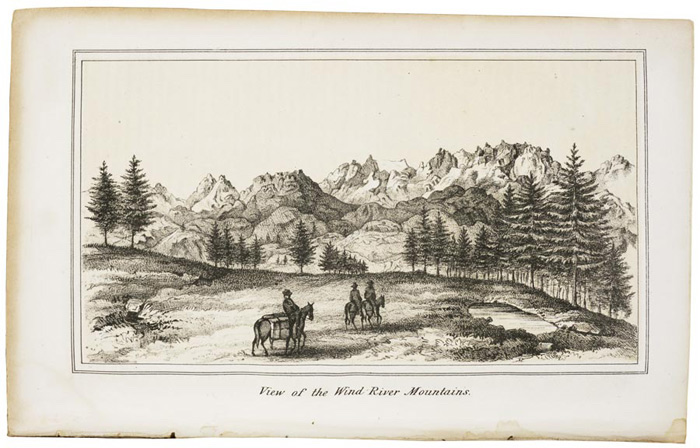
On Aug. 13, 1842, Charles Preuss — the cartographer on John Fremont’s mapping expedition of the Oregon Trail from the Missouri River to the Continental Divide — set up his materials deep in the Rocky Mountains and sketched the scene before him.
The landscape he depicted, which features a spiny ridge of peaks, became the first image of the Rocky Mountains published in a government expedition report.
More than a century later, a retired University of Wyoming professor with an unquenchable curiosity got to thinking about that image. Where exactly, Conrad Smith wondered, did Preuss sketch the drawing from?
That question sent Smith on an epic quest that entailed nine years, several gear-laden trips into the Wind River Range, more than one chartered flight, thousands of hours of research, a documentary film crew and more trigonometry than an average person would want to crunch in a lifetime.
Finding Preuss’s perch “turned out to be a lot more difficult than I imagined,” said Smith, 81.
Fortunately, he added, “obstacles motivate me.”
A bottomless curiosity
Smith, who taught journalism and communication at UW, pursues passions with an enthusiasm that can slide into obsession. Though photography is just a hobby, for example, his arsenal of camera gear would fill a Sprinter van.
He is also a keen outdoor enthusiast who has trekked untold miles through Wyoming’s high country. His interest in finding Preuss’s viewpoint was piqued in the early 2010s, he said, while reading the 1960 “Guide to the Wyoming Mountains and Wilderness Areas,” by Orrin and Lorraine Bonney.
He noticed something that didn’t line up: The book’s description of the explorer’s 1842 ascent of a peak in the Winds appeared to be wrong.
“Clearly the mountain he said Fremont climbed was not only not the mountain he climbed, but not the mountain it was labeled as,” Smith said. “…And that got me curious.”
That led Smith to the 1842 drawing, which cemented a determination to verify precisely where the drawing was made.
The task turned out to be not at all straightforward.
An epic search
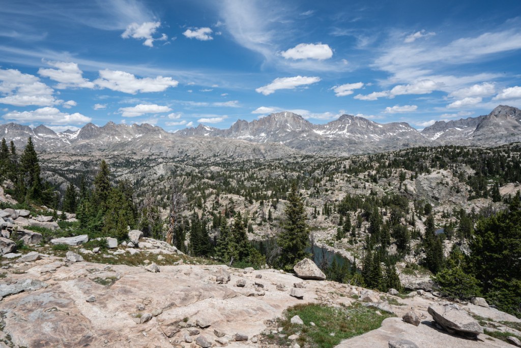
Smith returned to the Wind River Range every year from 2013-2017 to scour an area near Seneca Lake where he believed Preuss made the drawing.
From the expedition notes, he knew where the men had camped, he said. But foot travel across the terrain alone did not yield success.
“I kept looking for something that looks exactly like the drawing,” he said. “I kept coming to dead ends.”
Smith also tackled the complex challenge of accounting for dimensions, shadows and their corresponding hours of the day, latitudes, topography and sightlines. The work entailed many trips back to the drawing board and loads of math.
“I did a lot of trigonometry,” he said.
He poured over maps, and chartered Cessna flights out of Casper and Afton to circle over the mountains. On those plane rides, he snapped hundreds of photos, which he later combed over with painstaking attention.

He also dug into historic records and research (including purchasing a pricey original copy of the Fremont expedition report). A key breakthrough came when Smith discovered a truism about early expedition drafting, he said: Objects were not depicted to scale, and engravers on the East Coast would often add vegetation and figures to landscapes after the fact.
“It was a eureka moment when I realized that the traditions of publication, the traditions of landscape drawing in the 19th century, were completely different from photography,” he said. “I assumed that [the drawing] from the expedition report was meant to be an exact representation.”
Instead, he discovered that landscape artists eschewed proper scale and shrunk the foreground in order to emphasize the background.
“One of the trees in the drawing, if it were in the location where it’s placed, it’d be 2,000 feet high,” Smith said.
With those epiphanies, Smith began to zero in on a location.
Doctor’s orders
As the mission stretched into years, health issues presented other hurdles.
One trip into the mountains left him with a bleeding ulcer. On another, he suffered from altitude sickness. He also experienced irregularities with his oxygen saturation, he said, which prompted his doctor to advise him at one point against returning to the mountains.
That is why, in the summer of 2019, his daughter and granddaughter headed into the Winds in his stead — armed with Smith’s directions to find what he believed to be the rock on which Preuss perched.
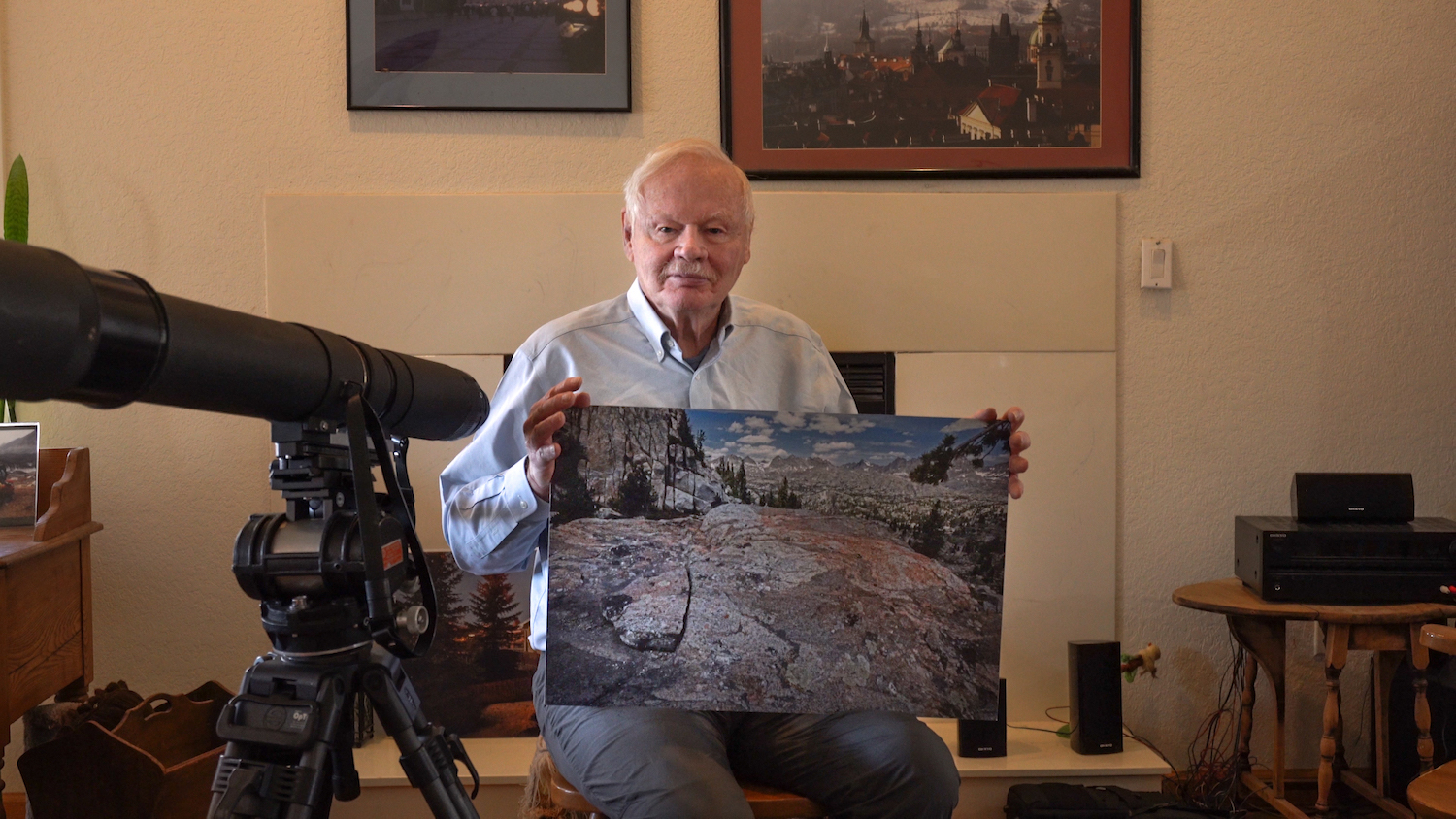
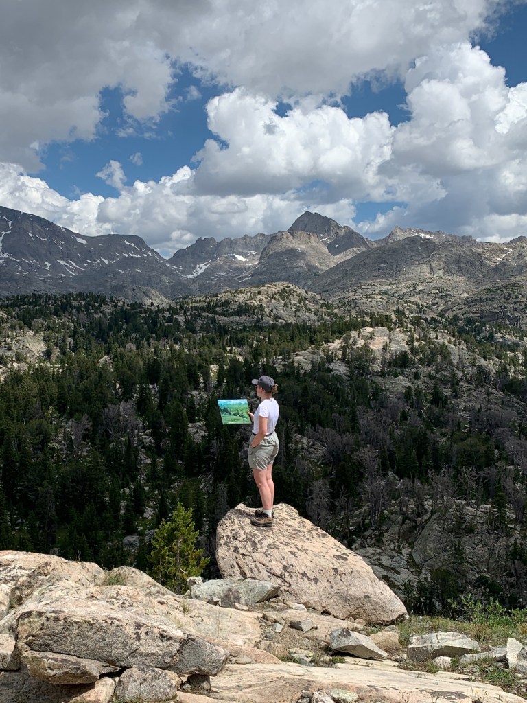
On that trek, Deirdre Smith and Irja Sandvik discovered a van-sized boulder high on a slope strewn with rocks. The boulder was flat on top, spacious enough for an artist to stretch out, with a view of the ridgeline that lined up with the drawing. They documented it carefully.
This, Smith decided after viewing their photos, was it.
But … could he be sure? He hadn’t seen it for himself, after all. That old curiosity began to gnaw anew.
And so, the following summer, he returned to the mountains — the oxygen saturation issue is only intermittent after all, he said. Once there, he trudged up to the boulder and climbed on top so he could see with his own eyes.
From up there, a breathtaking vista of Mount Arrowhead, Mount Helen and Fremont Peak unfolded before him. His confidence solidified.
“It was satisfying,” he said of the culmination of thousands of hours of obsession.
Immediately, though, new questions popped up. Did the artist, who was short, stand on a kettle to give himself a couple more inches of height?
Smith’s gears began grinding again.
A film chronicles the story
A few years into the quest, Smith’s story piqued the attention of a former student named Mark Pedri, who makes documentary films with his wife, Carrie McCarthy.
Between the fascinating tale and Smith’s outsize personality, Pedri said, they couldn’t resist making a film.
“Conrad is a national treasure, I like to say,” Pedri said of his former thesis advisor.
Normally, Pedri said, their company Burning Torch Productions conducts more pre-filming and research. But with such a colorful personality, he said, they had to seize the opportunity.
The film crew joined Smith’s daughter and granddaughter on their 2019 expedition, and filled in the rest of the story by interviewing Smith in his home.
The resulting 28-minute film, “Morfar’s View of the Winds,” debuted at regional festivals, and PBS picked it up this fall for a three-year broadcast schedule.
It offers a wry look at a singular Wyoming life. (The film’s title is a reference to the Norwegian word for maternal grandfather — Smith’s granddaughter calls him morfar.)
Smith is an exemplar of how to stoke the fire of purpose in life, Pedri said.
Even as an octogenarian, he said, Smith is “still going into the mountains. He’s still finding ways to keep going and push his limits.
“It’s just kind of an inspirational story about finding ways to, you know, continue to chase your passion, even when your body starts to find reasons why you shouldn’t be there,” he said.
Smith acknowledges that only an obsessive person would spend so many years and dollars and resources on a mission that some might consider trivial.
“In the larger scheme of things, this doesn’t change very much,” he said. But “it was interesting to me.”
So now that he has finally come to the end of this long puzzle, what’s next?
When this question is posed to Smith on a recent afternoon, he perks up. He’s got a few ideas kicking around, he says.
“That is a good question that I’ve been brooding about,” he says, “because I need a project to keep me occupied.”
“Morfar’s View of the Winds” is available on the PBS app or through video on demand.
Pretty much a Wyoming border collie.
Great stories about Professor Conrad Smith and artist Chris Amend in today’s issue. I called Prof. Smith to help me get oriented as to the location he believes is the point from which the Fremont Expedition drawing was made, and as to the direction in which the artist was looking. He says the vantage point’s latitude/longitude is 43.0664N and 109.6664W, just west of Little Seneca Lake (Bridger Lakes quadrangle map). This location is close to being directly south of both Henderson Peak (which is a peak in the middle of the drawing) and Gannett Peak beyond (not quite visible from the vantage point). These points, along with Arrowhead (west of north) and Mt. Helen (east of north), are on the Gannett Peak USGS quadrangle map. Fremont Peak is slightly further east of north on the Fremont Peak South and North quads. Fremont, Helen and Gannett are on the Continental Divide.
A Sweet story and one that serves as a good counterpoint to your story on the BLM’s work on preserving the Sage Grouse’s natural habitat through limiting Wyoming’s dire efforts to eat coal.
Do you think Gov. Gordon read the Interior’s 2020 report on CO2 emissions?
He probably eats Grouse on a weekly basis.
Idk, looks like a wild guess as to a match, and like a great waste of time. Certainly, we all have our moments and sometimes great adventures and discoveries come from them.
As to “the book’s description of the explorer’s 1842 ascent of a peak in the Winds appeared to be wrong”, nice catch if true. Too many people, journalist included, just accept things they read as fact.
Interesting counterpoint to disparage a persons obsessive search for verification and accuracy with the observation that we should disbelieve the things we read. I am confused.
John,
I said it LOOKS like a great waste of time, not that it IS a great waste of time. One person’s quest can certainly be unquestionably significant for them, but seem less significant to others. They are not conflicting ideas just different viewpoints about the obsession. As an example, and putting aside the methodology, many people probably thought Trump’s efforts to stay in office was an obsessive search for verification and accuracy with great value. Others disagreed.
Either way, all sorts of great things can come from an obsessive pastime. And as I pointed out, what looks to be a waste of time is often not. Most of the people I know think my obsessions are pretty meaningless, especially to them. I don’t really disagree. I see it for what it is. It’s for me not others.
Reminds me of David Love. He used to tell stories of places in the mountains that he refused to write about or publish: unknown medicine wheels, dinosaur tracks, etc.