
A swarm of small earthquakes in Yellowstone National Park has scientists inquiring whether they may indicate potential activity along a killer Yellowstone earthquake fault line.
The swarm is a cluster of more than 1,284 temblors since June 12 near the west edge of the national park. It’s part of the Yellowstone supervolcano’s personality, a geophysicist says. Several such swarms have occurred in recent years, as expected from Yellowstone’s fractured near-surface geology, underlying heat, and hydrothermal activity.
A supervolcano that last erupted 640,000 years ago, Yellowstone remains “a living, breathing, shaking, baking, caldera,” University of Utah geophysicist Robert Smith says. As such, the swarms — a series of small quakes clustered in time and space — are part of the normal course of events.
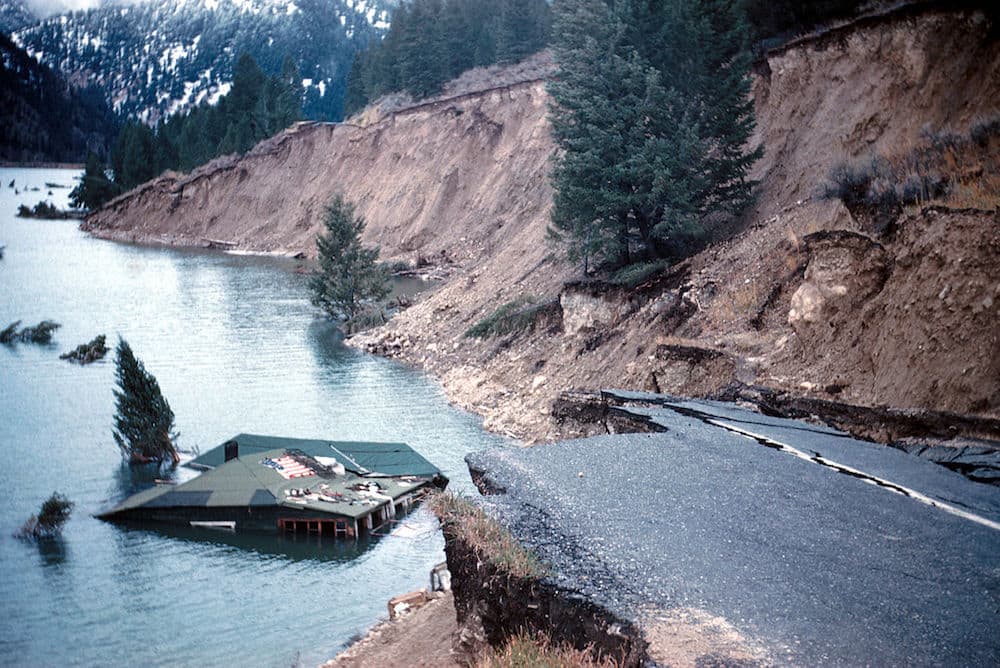
But while past earthquake swarms have been seen by scientists as routine, the location of the most recent cluster has them wondering whether it might be related to the notorious Hebgen Lake Fault. That fissure just west of Yellowstone slipped in August 1959, in a magnitude 7.3 earthquake.
The quake killed 28 persons in Montana, caused $11 million in damages ($89 million in 2014 dollars) and created Quake Lake outside the town of West Yellowstone. Smith talked about the potential relation between the swarm and the killer fault in a presentation to Geologists of Jackson Hole last month, and in subsequent interviews.
The Hebgen Lake Fault is some 25 miles long and its east terminus is “roughly where this swarm is beginning,” Smith said.
Interest is keen because a normal swarm of Yellowstone earthquakes would be relatively insignificant. If the swarm is associated with the Hebgen Lake Fault, however, scientists wonder whether it could be a harbinger of deadly quake on the order of the 1959 event.
Yellowstone earthquake swarms vs the real thing
The difference between quake swarms emanating from smaller fissures in the volcanic crust and movement along the Hebgen Lake Fault is significant. The former are characterized by small, frequent events while the latter can produce infrequent, big, dangerous ones.
The Hebgen Lake Fault is tectonic, involving continental plates. Volcanic swarms involve small fissures in shallower magma crusts and are likely caused by moving heated fluids and gasses.
After analyzing a Yellowstone swarm from 2010, scientists at the U.S. Geologic Survey’s Yellowstone Volcano Observatory determined the shaking took place along a pre-existing crustal fault system. The quakes migrated up, down and sideways. Pressurized fluids and gasses triggered a rupture that started about 6 miles deep and shook an area on and off for three weeks.

“Volcanos have a lot of swarms,” Smith said. “Swarms are a common release of energy. [In Yellowstone,] we get 200 to 300 earthquakes a year. In swarms [earthquakes] are closely spaced in time and space and build up kind of to crescendo and then they die away.”
In contrast, the Hebgen Lake quake of 1959 instantly ripped open a scarp as tall as three people just west of the park. The fault can be seen on the surface where it fractured. But to the east, the fault dips below ground in a direction “that would be implied to extend beneath Yellowstone,” Smith said. Atop the fault would lie Yellowstone’s volcanic deposits and heated fluids.
“Is this [swarm] an extension of the Hebgen Lake Fault, this zone of earthquakes?” Smith asked. The swarm extends for about 6 miles. “It’s a pretty substantial area involved,” he said. Determining any relationship between the swarm and the fault, “in my opinion will be of great importance.”
Smith calculated the comparative risk of Yellowstone geologic events and says there’s a 0.00014 percent chance each year of a caldera-forming eruption. Meantime, a significant earthquake is 878 times more likely to occur in a given year — a 0.123 percent chance.
A volcanic eruption would be dangerous, but eruptions are infrequent. Yellowstone’s not ‘due’ for another for 70,000 years. Consequently, eruptions pose little risk.
After calculating the chances of eruptions, hydrothermal explosions, fault slips, rhyolitic flows and other geologic events, Smith estimated their relative dangers. Earthquakes make up about 95 percent of the geologic threat to people in the region.
“The biggest hazard is an earthquake, not volcanic eruptions, despite the press,” Smith said.
The press, especially in Great Britain, goes gaga over the supervolcano and potential disaster every time Smith and his colleagues report a swarm. ”I’ve been trying to debunk the supervolcano thing and trying to get back to reality,” Smith said. He seeks to counter “soothsayers and whatnots [who] further their interpretation that Yellowstone’s got imminent this and imminent that.”
Tabloids love the topic. “Is it about the blow?” asked London’s Daily Mail. “Fears Yellowstone supervolcano that could cause 90,000 deaths may be about to erupt as it is hit by 400 earthquakes in just ONE WEEK,” crowed The Sun.
Fire or ice?
Emergency officials in nearby Teton County undertake what’s known as “all-hazards planning” when preparing for natural disasters. They consider the potential of destruction from the supervolcano, as well as from an earthquake along the obvious Teton Fault, and other threats. The Teton Fault created the world-famous mountains of the same name and could create an equally impressive disaster.
“Teton County is one of the, if not the most at-risk county in Wyoming when it comes to earthquakes due to the number of potentially active faults within and near the County,” a summary of one assessment says. “It is estimated that if a worst-case event occurred in Teton County, $681 million in combined capital stock and income losses could occur.”
As many as 3,222 buildings — 64 percent of the total — would be moderately damaged, and 379 destroyed. Again, however, risk must be assessed.
With earthquakes, “you have something that has great potential to cause a lot of damage,” said Rich Ochs, head of Teton County’s emergency management. But he keeps quakes in perspective in the same way Smith views volcanic eruptions.
Never miss a story — Subscribe to WyoFile’s free weekly newsletter
Turns out if one is to experience an unplanned demise in Teton County, it is likely to be under mundane circumstances. “Probability-wise, far and away what kills more people in Teton County than any other natural disaster is winter,” Ochs said.
The “big three” dangers that Ochs focuses on are floods, fires and winter. “You’re trying to balance probability with what the impacts will be,” he said. “If you ask people on the street, they’re concerned about the supervolcano. But the probability of that occurring is so low it shouldn’t be on the radar.”

Thanks for this article and the perspective! As always, informative and thorough, and a pleasure to read.
So very little is actually known about the actions and effects of quake faults east of the Rockies! We learn about them – length and depth – when a quake actually happens. We definitely need more research – especially in WY’s seismically active zone!!