

The U.S. Forest Service will likely not consider conservation alternatives to a plan that would enable irrigators to draw down New Fork Lake by 22.6 feet, an official said last week.
The Bridger-Teton National Forest is awaiting completion of a draft environmental assessment on plans to rebuild a dam and lower the outlet at the popular recreation lake in the national forest near Pinedale. The study likely won’t consider a conservation alternative to the drawdown, the acting Pinedale District Ranger told WyoFile.
That option — lining canals and converting flood irrigation to sprinkler operations — has been shown in a study commissioned by the Wyoming Water Development Office to produce more irrigation flows.
The district ranger had said previously that the conservation alternatives should be considered as part of the Forest Service review under the National Environmental Policy Act. The U.S. Environmental Protection Agency backed that assessment in a letter to the Forest Service in April.
The conservation alternative, however, is apparently no longer on the table, said Mark Bingman, acting district ranger for the Pinedale Ranger District for the Bridger-Teton.
“I don’t think we are looking at those alternatives as part of that [environmental assessment] process,” Bingman said. “We are looking at the proposal in front of us — what happens on forest lands.”
A conservation alternative would require irrigators to alter operations on their own property, something “we don’t have control over,” Bingman said. The Forest Service will consider “just what’s occurring on forest land,” he said.
Other agencies weigh in
The EPA, U.S. Fish and Wildlife Service and Wyoming Game and Fish Department backed examination of conservation, warned about potential adverse effects to downstream fisheries and made other recommendations in official agency comments on the scope of the pending environmental analysis. The EPA also recommended the plan look at additional methods of rectifying the irrigation shortfall.
“Additional alternatives to consider for agricultural shortages include rotational fallowing, dry year leasing, gravel pit storage, acquiring and utilizing existing storage from reservoir companies, expansion of non-potable supplies, developing wastewater reuse infrastructure, acquisition of additional shares of irrigation company water rights or purchase of additional water rights in ditch companies,” its comment reads.
The Forest Service also should separate two elements of the project — rehabilitating an old, unsafe dam and supplying more irrigation water, the EPA wrote. The environmental analysis also should describe historic impacts to streams and wetlands. Construction of the original dam in the early 1900s appears to have inundated and destroyed wetlands at the lake’s east end through repeated flooding and draining.
“The protection, improvement and restoration of wetlands and other waters of the U.S. are a high priority because they increase landscape and species diversity, support may [sic] species of western wildlife, and are critical to the protection of water quality and designated beneficial water uses,” the EPA wrote.
In its comments the U.S. Fish and Wildlife Service looked downstream, writing that “federal agency actions resulting in water depletions to the Colorado River system may affect the endangered bonytail [chub], Colorado pikeminnow, humpback chub, and razorback sucker, and their designated critical habitats.”
The federal wildlife agency also warned against bothering eagles, including bald eagles that nest in the area.
Wyoming Game and Fish recommended a minimum in-stream flow for the New Fork River below the reservoir, underscoring how popular the river and lake are and how the project could disrupt fishing, fish habitat and anglers’ experiences.
“The operation of the dam will affect the entire length of the New Fork River fishery,” Game and Fish wrote. “Impacts to the natural reproduction of these species will likely decrease the quality of this popular fishery,” the agency comment reads.
Operations would affect fish in the lake, too, Game and Fish wrote. “Reservoirs that fluctuate a lot have poor recruitment and generally marginal fisheries,” the agency’s letter to the Forest Service said. Lake-bank erosion could destabilize landslides along the lake shore, the agency wrote.
Purpose and need
The state selected the plan to reconstruct the dam and lower the outlet as its preferred alternative in 2017 after consultants RJH Consultants Inc. recommended that proposal. The state had tasked RJH to study what the state determined was an average annual irrigation shortage of 6,700 acre feet on 14,613 acres in the New Fork Irrigation District.
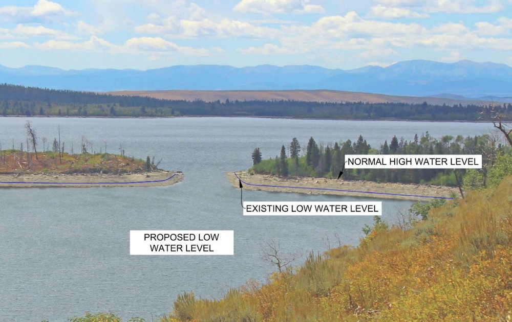
The $12.7-million project would reconstruct the existing dam at the lake’s outlet and build a new, lower outlet. That would enable irrigators to lower the surface of the 1,070-acre lake by 22.6 feet, 7.4 feet lower than could happen today.

“Lowering the outlet structure effectively increases the amount of water actively stored at New Fork Lake without increasing the surface area of the existing lake,” the Forest Service wrote in a March 17 announcement launching the project review.
In other words, though it would impound no additional water, the storage project would make more of the lake available to irrigators by lowering the controlling drain at the reservoir’s outlet. The result would, nevertheless, divert more water from river flows in the Colorado River basin to be poured on the land.
The existing dam, about 10 feet high, is a high-hazard structure that can’t safely pass flood waters. It includes a sub-standard bridge used by recreationists. Those deficiencies would be corrected during reconstruction.
RJH Consultants’ 479-page report in 2017 said conservation — lining ditches and using sprinklers instead of flood irrigation — would do more to reduce the average annual irrigation shortage than reconstructing the dam and lowering the outlet, the study said.
Conservation would reduce the shortage from 8% to 3.9%, according to RJH’s findings. The proposed plan to lower the lake level would reduce the shortage from 8% to 4.9%.
Calculated another way, conservation would reduce shortages by an average of 44% more than the proposed plan.
“With conservation, you’ve got more water than with the [lake-lowering] enlargement,” Jason Mead, director of the Water Development Office’s department of dams and reservoirs, said in 2017.
RJH didn’t recommend conservation as a preferred alternative, or an alternative at all. Its contract with the state contained sideboards directing the firm toward a preferred alternative calling for new storage.
RJH’s contract with the state called for making additional storage a priority, beginning with a “purpose and need statement” the company had to write. That statement is considered critical in federal approvals.
The Water Development Office had to approve an RJH purpose-and-need statement “for additional storage,” according to the contract. After statement approval, RJH had to develop “a long list of storage alternatives,” and then screen for the “top three (3) storage alternatives,” the contract reads.
New players
In 2016, the Bridger-Teton gave RJH its view of the requisite considerations. “All projects proposed on federal lands require … full analysis of all possible alternative [sic] located on or off federal lands,” the Forest Service wrote the consultant as it prepared its 2017 report.
RJH appeared to discount that comment, saying it would be “very unlikely that a more rigorous analysis will result in a different alternative being identified as the preferred alternative.”
Nevertheless, Pinedale District Ranger Rob Hoelscher was confident in 2017 that the Forest Service would consider conservation during its own, separate environmental analysis, the one that’s underway today. “You would want to consider all those other things, like efficiencies, so you could compare the impacts of the project on that wide range of alternatives,” he said.
Project supporters say there’s a question of practically regarding a conservation program.
“Piping [or lining] all of the ditches — you would improve efficiency, [but] the likelihood [is] that would be a very large undertaking,” Mead, the WWDO deputy director of dams and reservoirs, told WyoFile in 2017. “It’s cost-prohibitive, at least through our program, to implement that.”
Water Development Office Project Manager Andrew Linch in 2017 described the RJH New Fork Lake study as “a storage project — not a [study to] look at the economics of application efficiency.”
The Forest Service may not need to consider conservation when it studies the plan in its ongoing environmental analysis, Linch suggested at the time. “I don’t know if conservation would fit in [the parameters of] their special-use permit” that authorizes New Fork Lake use, he said.
Bingman, the acting Pinedale District Ranger, said if irrigators were proposing a new reservoir on national forest land, the environmental analysis would have to look at alternative sites on private property. In such an instance, the agency would have a significant voice, he suggested.
The Forest Service would not, for example, be able to justify development of public property for a reservoir simply because it would be cheaper than a private option. In studying new reservoir sites, “it doesn’t matter to us how expensive,” a private-property alternative is, he said.
But the drawdown plan is different, he said.
“In this instance, it’s kind of a challenge,” Bingman said. “I don’t know how you get access to this water except for where it is.”
As long as the irrigation district is in compliance with its existing permits, “we don’t have anything else to look at,” other than its request to lower the lake level, he said.
Recreation
In a public presentation, forest officials promoted the lake-lowering plan. “Lowering the outlet works at New Fork Lake had the least environmental impacts compared to the other options and meets a portion of the New Fork Lake Irrigation District’s identified irrigation needs,” a power-point presentation prepared for a public meeting in 2020 reads.
The agency took public comment for 30 days, as required by law, beginning March 26.
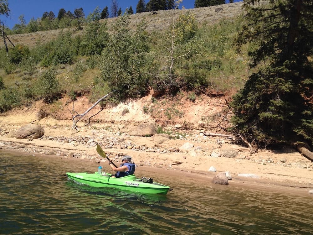
The lake on the northwestern edge of the Wind River Mountains is within 400 feet of the boundary of the Bridger Wilderness, according to maps, and is popular among hikers, campers, boaters, anglers and others. Among the issues the environmental analysis will address are short- and long-term effects on a boat ramp and dock, a scout camp along the lake’s shore and other recreational uses.
“Those are considerations they definitely need to look at,” Bingman said. Also, “we are concerned about the aesthetics,” Bingman said.
One of those concerns might be with what would be at least a 22.6-foot-high bathtub ring of erosion exposed at the lowest drawdown after reconstruction.
Graphs from public presentations show that irrigators would have used a lower outlet more than half the years — 21 years out of the 38 years — from 1981 to 2018, had it been available.
One element of the reconstruction plan would address the narrows — a connection between two parts of the lake that becomes shallow at existing low-water levels. Under the reconstruction plan, boats would be blocked from reaching the eastern portion of the hourglass-shaped lake when the lake level approached drawdown.
To address that, workers would dredge a deeper channel at the narrows. They would first have to build a road to the site.
The Forest Service is in contact with the Wyoming Game and Fish Department regarding the project and its effect on fish, among other things, Bingman said. Game and Fish sets up a kokanee salmon trap at the lake inlet in the fall as part of its salmon rearing and stocking program.
The project would aid 94 irrigators, support 530 additional cattle with an overall area agricultural benefit of $496,000 per year, according to RJH’s 2017 study.
Irrigators might have to pay as much as 35% of the cost of the project, or as little as 10% through low-interest loans, according to scenarios sketched out in the 2017 study. The balance would likely be provided by the state, which could also finance any loans.
How shortminded.
Given that CLimate Change is causing Wind River Mountakn glaciers to recede at a trot and future snowpacks almost certainly will decline, it seems logical that increasing gross storage and not drawing down the waterline is a no brainer. Even for the Forest Service, who seems to have an acute case of myopia here.
I’m postulating the underlying reason for not going the full NEPA analysis route here has a lot more to do with the Trumpian ideology that despises things like NEPA , the EPA, and anything conservationwise that might be tinted green. Hopefully that mindset will soon be in remssion after November 3.
Great article as always Angus. Just wondering if you might do one on traffic and a possible urban gondola system? Keep up the good work!