
It’s kind of like pouring beer, from a bottle, into a frosty mug. Done right, the last drops of refreshing beverage dribble from the bottle just as the foam reaches the rim.
Easy enough. Except when you swap spring runoff for beer, and Wyoming’s reservoirs for the frosty mug, it gets complicated in a hurry.
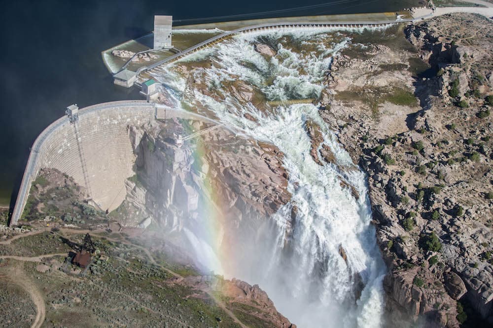
For starters, your “mug” has an adjustable drain in the side, and is already partially full. The “bottle” you’re pouring from is enormous, and, though, you can estimate how much liquid is in it, you have no way of knowing when it’ll come gushing out or how fast it will pour.
![]() Worse yet (and here’s where the beer simile breaks down) overflow spills are catastrophic. Insufficient fill, on the other hand, is only moderately better.
Worse yet (and here’s where the beer simile breaks down) overflow spills are catastrophic. Insufficient fill, on the other hand, is only moderately better.
The livelihoods of hundreds of farmers and ranchers, the functioning of our electrical grid, the integrity of interstate water compacts, a multi-million dollar water recreation and tourism economy, the survival of innumerable fish and wildlife, and the life-or-death safety of many riverside communities all depend on getting it right.
Mohanri Williams describes the stakes a bit more succinctly. “Water is pretty important,” he said. Williams is the supervisory engineer for the Resource Management Division of the Wyoming Area office of the Bureau of Reclamation.
Such sober understatement coming from the federal agency that operates dams and canal systems throughout the West is comforting.
In Williams’ case it’s also a fair reflection of his temperament. Asked recently what percentage of the snowpack runs off in May, June and July, for instance, he quietly produced a Casio calculator from his pocket and opened a three-ring binder full of numbers.
Data are the key to determining how much water to send through each of 28 dams around the state, and when. Two measurements, in particular, dominate the inflow v. outflow balancing act: How much moisture is waiting in the mountains, and when will it come down?
So start amassing information.
Eighty-five high-tech “Snotel” monitoring sites sprinkled throughout the Wyoming high country provide a pretty good estimate of water volume.
This year’s tally is off the charts. The Wind River Range, for example, may contain more frozen water than at any other time in recorded history.
When, precisely, the big thaw will send all of that water careening toward Boysen Dam, and at what rate, is anyone’s guess.
So, on to step two. Open the spillway, stat.
If you start dumping water early enough, you should be able to minimize the flooding, erosion and general havoc that come with big releases. But if you wait too long, and fail to create enough space for the liquid battering ram that’s headed your way, Mother Nature will set the terms.
Nobody wants that, not in a record runoff year, least of all the inhabitants of Thermopolis, Worland, Casper, Guernsey and other low-lying towns situated downstream of large reservoirs.
An adequate head start should help you sleep nights when, in late May, reservoir levels start climbing despite what you’re sending through the dam.
Never miss a Know How — subscribe to WyoFile’s free weekly newsletter
Keep crunching and re-crunching the numbers. Adjust, as necessary, for spring storms and other unanticipated changes. Hope the models hold true with such an astronomical snowpack.
You’ll have a new reason to bite your nails when the rivers finally slow. Did you close the spigot early enough or let too much out? Will there be enough water left to refill the reservoir?
If all goes to plan, you should have the answer by late summer.
And if you did the math correctly, you may just get to pour a celebratory beer.