
Devin Butler could see the arch in the distance. Then it disappeared as he descended a hill. Atop the next climb he saw it again. It teased in and out of view this way, never seeming to grow closer. He was still 10 miles away.
The bridge, he knew from research, was big. But it’s almost mirage-like appearance and disappearance gave him a new appreciation of its massiveness. Butler wanted to know how big it really was.
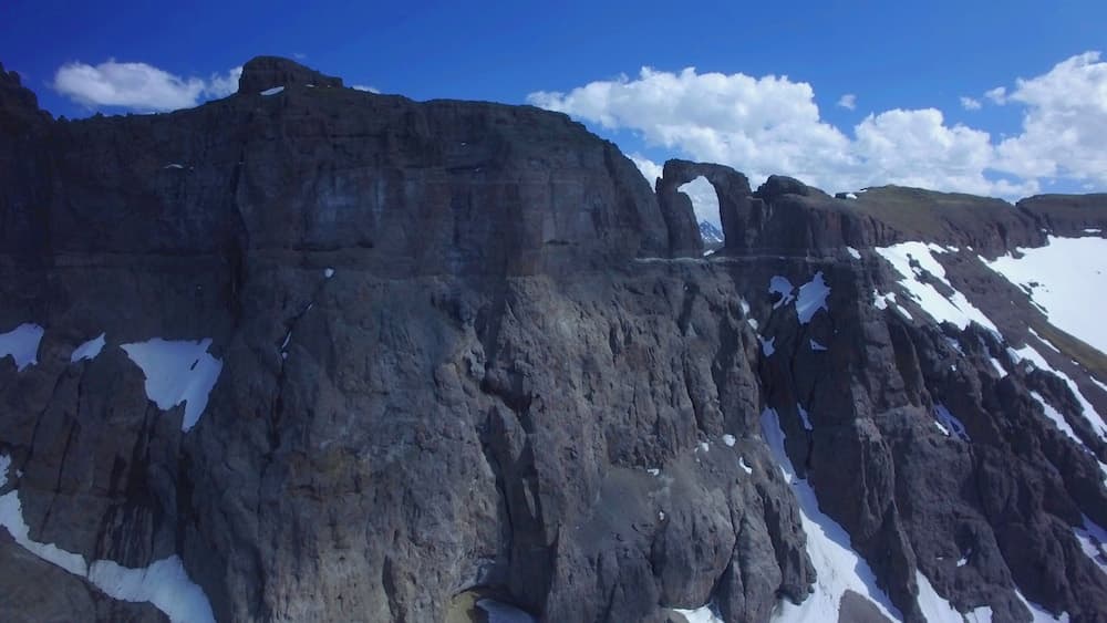
Blackwater Natural Bridge is a natural arch hidden deep in the backcountry of the Shoshone National Forest. It is believed to be one of the largest natural arches in the world, but its remoteness, arduous approach and inaccessible position 1,000-feet above a meadow has left it un-measured and unsurveyed.
Butler, a 31-year-old Casper electrician, was enroute on June 17th with his drone, in an attempt to change that.
He’d been researching an arch near Alcova when he learned of the Blackwater Natural Bridge. A Wyoming native, he hadn’t heard of the natural arch. He was immediately intrigued.
Online research yielded little, only that the arch was about 14 miles deep in backcountry on a poorly maintained trail and that some suspected it to be the world’s largest.
All the pictures he found of the bridge were from the distance. There was no official measurement of the natural feature. And few people make the arduous hike to see it.
The dearth of information about Blackwater Natural Bridge struck him as an an opportunity.
Butler bought his first drone in 2016 and it transformed how he saw his home state. He took in Hell’s Half Acre from the sky, flew through the tight walls of Fremont Canyon and viewed the spill at Pathfinder Dam up close. His drone opened new frontiers for him to explore.
Butler thought the drone technology could help him take pictures from different angles and provide a fresh perspective on the Blackwater Natural Bridge. Using GPS-tagged photos he might also be able to build a three-dimensional model and determine the height, width and span of the arch.

Butler is not the first to fall under the arch’s spell. Nor is he the first to want to measure it.
Dewey Vanderhoff, of Cody, first visited the arch in 1973 when he was 22 years old.
The arch is special, Vanderhoff said. Unlike most natural arches in the world, Blackwater Natural Bridge is carved from volcanic rock, not sedimentary rock like Utah’s famous sandstone arches. He returned many times, always keeping the location secret.
Vanderhoff calls the arch “a wicked mistress.” A naïve hiker could die trying to find his or her way out of the south abutment of the arch, and the north is totally inaccessible, he said. It can’t be approached from below without technical climbing skills. As far as Vanderhoff knows, no one has ever stood on the arch. Local legend says a man once flew an airplane through the aperture, but there is likely little truth in the story.
Vanderhoff has also long wanted to measure the arch and determine its standing in the hierarchy of natural arches around the world. He’s created rough measurements using his photographs and trigonometry, factoring in the placement of the sun, the elevation and the distance he was standing from the arch when the photos were taken. He believes Blackwater is likely one of the five largest natural arches in the world. Sitting at 10,000 feet he’s confident it’s the largest at such elevation. But he never knew for sure.
Years ago, Vanderhoff attempted to organize an expedition with a pair of climbing guides. The plan was for the guides to climb the arch with measuring tools such as surveyor’s tapes, while Vanderhoff took pictures and used a theodolite, a surveying tool used to measure angles. The expedition was shelved when one of the climbers had a family emergency days before they planned to leave. They never rescheduled. The bridge kept its secrets.
Then, in 2017, Butler secured the necessary permits with the Forest Service and convinced his friend Kris Dennis to accompany him. Butler planned to make a documentary about the expedition and the bridge. Armed with camping gear, topographic maps and videography equipment they set out on June 17.
Get Wyoming wild-country stories delivered to your digital doorstep each week with our free newsletter.
That was the last thing that went as planned
The gradual incline they’d expected was in fact a relentless series of steep ups and downs that made Butler’s knees scream.
They spent hours covering a short few miles. Water rushed down the trail… when there was a trail. The clearing they’d planned to fly the drone from was choked by timber.
“It was so much harder than we expected,” he said.
Butler launched the drone several times from an alternate site but couldn’t get close enough to take the images needed for a three-dimensional model.
He still plans to create a documentary of the attempt. What footage and GPS data he managed to capture of the arch may prove sufficient to determine at least the width and height of the arch, he said. That will have to do.
“I don’t think we can go back,” he said. “I think that might be a once-in-a-lifetime experience.”
So the mysteries of the arch persist. At least until the next intrepid explorer, armed with the latest technology tries again.


This is the “keyhole” in the China Wall my great old friend here on the Southfork of the Shoshone zRiver now deceased, Ras Bales and I took my 4by4 SUV up near to, drove through very rough terrain to get to. We did find it, but could not do the rough hike Ras had done at age 24, back then he had a pix made of him standing in what he called The “Keyhole in the China Wall.”
I did manage a clip of Ras standing in the sagebrush with the “China Wall” at his back and framed it for his wife, Pat.
Sadly, Ras passed away only a couple years later.
Is this in a Wilderness area?
The arch actually sits on top of a rim and on one side is wilderness, the other side is in the Shoshone NF. We stayed out of wilderness area and didn’t fly over it. There is a finger of NF that sneaks into the wilderness and includes the Blackwater Natural Bridge and Fire Memorial Trails.
Thanks Dewey! We actually got some really cool close up footage, but the problem was in the firmware for the drone. The 3d modelling requires multiple angles and elevations to produce something usable, and all the footage we got was head on. The drone has a barometric limit of 500 meters to help keep you out of faa controlled airspace (500m above ground level) and of course where we took off was enough to get level with, but not above, the arch.
We actually didn’t hit snow until we hit the meadow below the arch, though there was plenty of runoff. I was a little anxious to get up there, we would be had more luck if I wouldve had more patience!
It was very interesting to hear about your attempt, I’d love to compare notes sometime.
Best,
Devin
Do you have a blog/YouTube with more footage? Interested to see more of what you captured!
You can follow my page on Facebook (search for Phoenix Aerial Imaging) for updates on the documentary and where and when it will be screened. Now that I’m running a business a lot of the stuff I did before I tested for my license I can’t use for promotion because it was done as a hobbyist, but I’ve been trying to keep the fb page updated with cool stuff every once in a while.
Keep at it , Devin.
You would have likely succeeded and gotten good access had you not tried to negotiate that steep twisted trail in June of the highest snowpack strongest runoff year in a generation. That’s an arduous foot trail on it’s best day . Better to use a good mountain horse to get you to timberline. Late July would be better all around . I doubt the Forest Service would want you up there in August for reasons of protecting certain resources.
I’ve been up there on horseback in October , so it’s doable when everything aligns and the ground is dry .