

Wyoming’s top five elected officials told the state land office to explore a 24,000-acre land exchange with the Medicine Bow National Forest that could expedite construction of a 280-foot high dam in Carbon County.
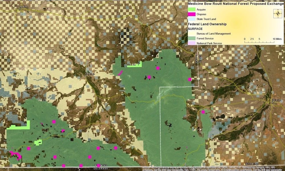
The State Board of Land Commissioners voted unanimously June 3 to support the investigation that conceptual maps show could involve some 12,000 acres of state trust lands in the Medicine Bow. That land would be exchanged for federal property on the forest perimeter plus about 1,350 acres at the proposed site of the West Fork Dam on a tributary of Battle Creek in the Sierra Madre mountains above the Little Snake River.
The values of the exchanged properties would be similar, according to state documents and meeting records. If appraisals value all acreage equally, the potential exchange could involve 24,000 acres or more.
“The idea behind this transaction is to change the ownership pattern” in which state lands are isolated inside the Medicine-Bow and difficult to capitalize on, Jason Crowder, deputy director of the Office of State Lands and Investments, told the land commissioners on June 3. Swapping the state lands for federal lands would enable Wyoming to sell timber and grazing leases and undertake other projects to generate revenue for state-land beneficiaries — mostly schools.
“There is another driver,” Crowder told the board; the proposed West Fork Dam and associated 10,000-acre-foot reservoir that the Wyoming Water Development Commission and irrigators want to construct on the West Fork of Battle Creek. The estimated $80 million (in 2017 dollars) project would benefit 67 to 100 irrigators.
That idea has been controversial, with critics challenging the economic underpinnings of the plan and legislators trimming the amount of appropriated money sought by the Water Development Office. Lawmakers also want Colorado irrigators to pay part of the costs — according to their 26% share of the 20,000 irrigated acres the reservoir would benefit.
The dam would create a reservoir that would inundate some 100 acres of federal land, plus some private land owned by a mining company. It would be more difficult and potentially impossible to construct the dam and reservoir if the site remains federal property, Crowder told the commissioners.
“The Wyoming Water Development Office was looking for a way to help facilitate the construction,” Crowder said in an interview. “They were running into a bit of a roadblock with Forest Service on Forest-Service-managed land.
“So … the Water Development Office has approached us and they’ve asked, possibly [if] we could do an exchange with the Forest Service,” Crowder told the land commissioners, “where we would make that state land instead of Forest Service land, and then place the reservoir on top of state land at that point.”
Albany, Carbon land involved
The proposal involves land in Albany and Carbon counties, according to conceptual documents presented to the land commissioners. Maps indicate the equivalent of roughly 17 state school trust sections Wyoming would transfer to federal ownership — some 12,000 acres.
The land board, made up of Gov. Mark Gordon, Secretary of State Ed Buchanan, Auditor Kristi Racines, Treasurer Curt Meier and Superintendent of Public Instruction Jillian Balow, unanimously resolved to authorize land office director Jenifer Scoggin to analyze an exchange. The resolution states that the swap has the potential to satisfy the board’s trust responsibilities.

An exchange would create “a more contiguous area of state trust land and increase […] revenue potential; and … may support a community need by facilitating the construction of the West Fork Reservoir,” the resolution reads.
Sen. Larry Hicks, district natural resource coordinator for the Little Snake River Conservation District in Baggs, secured $250,000 for the State Lands and Investments Office to examine the exchange, Crowder told the board.
“We feel like that is enough money to do the environmental work on the larger land exchange,” Crowder told the land board. “According to the Forest Service, the land exchange is a relatively easy environmental analysis.”
Dam proponents have been talking to the Forest Service “for years,” trying to find a way to build the dam, Aaron Voos, a Medicine Bow spokesman told WyoFile. “We’ve had multiple meetings and communications.”
Two straightforward avenues for constructing the dam are problematic, Crowder told the board, either one likely requiring preparation of an in-depth environmental impact statement.
One avenue — obtaining a Forest Service special use permit for construction and operation — might not be successful, Crowder said. A second option — transferring Forest Service property directly to the Water Development Office — would be a “very lengthy and in-depth … process” Crowder told the board.
A third alternative — the larger land exchange plan backed by the land board — would involve “a relatively easy environmental analysis,” Crowder told the board, citing the Forest Service. State ownership of the dam site would free dam developers from “the whims of the federal government,” he told WyoFile.
Dam developers “would like that ease[ing] of administrative hurdles to get the reservoir on the ground,” he told the land commissioners.
Forest Service policy provides that “the environmental analysis should focus on the future use and management of the lands acquired and conveyed and the effect of the exchange on the lands that adjoin them,” forest spokesman Voos wrote in an email statement. “Where there is a reasonably foreseeable change in the future use of land involved in a land exchange (such as reservoir development), it would need to be considered in the environmental analysis regardless of the size of the land exchange.
“A range of land exchanges” have been discussed between the state and the Medicine Bow,” the statement said, “some of which … do not involve the proposed reservoir parcels.”
The Forest Service did not attend the land board meeting, Voos said, and the agency statement did not directly address some of the characterizations made there. “Clarification from the State would be needed regarding details of the proposed exchange being discussed,” the forest statement reads.
‘Parallel processes’
If Wyoming were to obtain title to the dam site property, it would lease that land to the Water Development Office with payments going to school trust beneficiaries, Crowder told the board.
Once built, the dam, reservoir and property could be transferred again, this time to the Water Development Office, to Carbon County, or some other entity, “where they [the Water Development Office and others] weren’t under the burden of the lease payment,” Crowder told the board.
The plan proposes “parallel processes,” Crowder said. The Natural Resources Conservation Service, an arm of the U.S. Department of Agriculture, would be the lead federal agency analyzing dam construction. The Forest Service, a separate Agriculture Department agency, would focus only on the larger land-exchange.
“It wouldn’t limit the environmental review at all,” Crowder told WyoFile.
The potential 24,000-acre swap grew after the Water Development Office approached the state land office, Crowder said. Instead of limiting an exchange to dam-site property, “we saw an opportunity to go big,” he said in an interview.
There are “all sorts of different size possibilities for that land exchange,” Voos said. “We have been discussing options all throughout what has been years for this proposed project,” he said.
“We are in constant discussion with state lands with those kinds of land swaps,” Voos said. “There is always discussion of consolidation of land management.”
If Wyoming’s investigation leads to a 24,000-acre exchange proposal, “that would be huge,” Voos said.
A swap would involve properties of approximately equal value, those involved have said. “That value isn’t just monetary,” Voos said.
What benefit an exchange has for the American public from a Forest Service perspective also must be scrutinized, he said. If, for example, Wyoming wanted a section of Forest Service land flush with water, it might have to swap similarly watered land of its own, he said.
Wyoming will conduct appraisals and other work based on the land board’s resolution, then return for approval from the board before approaching the Forest Service with the exchange.
Plan kept secret
The day before the land board’s June 3 public meeting, its members met via Zoom in a closed-door executive session where they heard the proposal, Crowder wrote in an email. The board then asked the land office to bring the matter to them, Crowder said.
The land office on June 2 then amended the next day’s public agenda to include the land swap as a walk-in matter. On June 3 the top five state officials met in a seven-hour, 22-minute session and spent about 10 minutes on the swap, which was the last agenda item and which had been publicized for fewer than 24 hours.

There were reasons for keeping the plan secret and considering it first behind closed doors, Crowder said.
The state lands office maintains a couple of lists of lands it would like to acquire or dispose of, Crowder told WyoFile, including a category I list that is confidential. “Anytime you look at acquiring a piece of property and you make that a public idea, you have an ability [to change] what that market may bear,” he said.
As soon as a potential acquisition is announced, “there’s an opportunity for the market to be impacted and the state [to] pay more than it should,” he said. This applies even to a government-to-government land exchange such as the one Wyoming is considering, he said.
Wyoming public meeting laws allow closed-door executive sessions “to consider the selection of a site or the purchase of real estate when the publicity regarding the consideration would cause a likelihood of an increase in price.” The proposed exchange meets that definition, Crowder said.
“Within our rules and regulations it does state all land acquisitions on the category I list are to be held in confidence by the office until the board makes it public,” Crowder told WyoFile. “We keep it quiet until the board makes it public at a public meeting.
“What the board approved was our ability to move forward in the analysis phase. The state land office then returns with a firm proposal for a public meeting.”
The public shouldn’t feel cut out of state decisions, he suggested.
“This isn’t the only time the board’s going to have an opportunity to hear from the public,” he said of the June 3 meeting. There will be another public meeting before the State board of Land Commissioners authorizes the land office to submit a proposal to the Forest Service, he said.
Pricey per-acre foot
The on-channel concrete dam would create a reservoir with a 130-acre footprint when full and have an average of 94 acres of water surface. The lake would be about 226 feet deep at the dam. Some of the acreage that would be inundated is owned by the American Milling Company of East St. Louis.
Proponents of the West Fork Dam describe “a model project” for the drought-plagued Colorado River Basin. Detractors fear a pork-barrel boondoggle in the making. A Wyoming Water Development Office study pegged public benefits of the project at $73.7 million, qualifying it for $73 million in state grants. That would relieve benefiting irrigators of the usual 33% funding responsibility, decreasing their commitment to 8%.

Critics have said the project amounts to a $700,000 subsidy to each involved rancher. Some legislators have said the per-acre foot price is 1,000 times the cost of other water in Wyoming.
The Savery-Little Snake River Water Conservancy District launched the dam and reservoir project with a request to the Wyoming Water Development Office, according to state documents. Proponents recently secured a $1.25 million grant from the Natural Resources Conservation Service, plus a similar amount from the WWDO, to conduct an environmental review under the National Environmental Policy Act.
Support independent reporting — donate to WyoFile today
U.S. Fish and Wildlife Service and the U.S. Environmental Protection Agency will be cooperating agencies, according to a project update presented recently to the Yampa White Green Basin Roundtable, a Colorado consortium of water users. The NRCS must evaluate agriculture, watershed protection, recreation fish and wildlife, water quality, flood prevention and municipal and industrial water supply, according to the update memo.
From the reservoir, 6,500 acre feet would be tagged for irrigation storage, 1,500 acre feet to maintain a minimum bypass flow in the West Fork of Battle Creek. “High elevation strategic storage … can mitigate the impacts of climate change while benefiting agriculture, rural communities, environmental improvements in water quality, fisheries, candidate [threatened and endangered] species and provide significant recreational benefits to the regional economy,” the memo states.
SURVIVAL IN A DROUGHT YEAR VS. 70 GOLF COURSES:
The western drought continues to intensify with extremely low levels in Lake Powell and Lake Mead. Many ranchers have already reduced their herd sizes by as much as 50%. At times like these, the importance of the hay production along the Little Snake River floodplain becomes of the utmost importance, not only to the ranchers, but to the economic health of the communities along the river. That hay production literally means economic survival to the livestock industry and it depends on the availability of irrigation water – either surface or ground water. Ranchers as far away as 50-100 miles from the Little Snake River irrigated fields will be buying the hay just in order to survive and get by. The value of upstream storage of irrigation water, such as the proposed West Fork reservoir would provide, is invaluable in years like this.
On the other hand, Las Vegas has 70 golf courses all utilizing water from The Colorado River and Lake Mead – and some of that water originates via the Little Snake. One old adage with irrigation water is ” use it or lose it “. Wyoming has not utilized our portion of the Colorado River water which has been adjudicated by several compacts ; and of course, the well known Supreme Court case affecting Arizona and Southern California. The feasibility of the proposed land swap and proposed construction of the West Fork dam and reservoir should be evaluated considering the improvement Wyoming would realize with respect to utilizing our share of the Colorado River water – which is the bigger picture scenario. Cost of the dam and other factors are very important; however, would you rather see the water utilized locally or watering 70 golf courses???
Utah is a prime example of the value of irrigated land. When you fly over Utah you see narrow stripes of lush green river bottoms surrounded by millions of acres of desert and semi-arid grass lands. We’re not too different. I’ve witnessed the benefit of thousands of water improvement projects in Wyoming over the years ranging from simple stock dams and wind mills, to large irrigation dams like Alcova and Pathfinder. Without these thousands of improvements, the productivity of Wyoming’s land would be much, much lower; and, certain parts of Wyoming would be almost impossible to ranch – ever been to Dull Center??
In summary, the economy of the towns and businesses along the Little Snake River are dependent on the availability of water – but so is Las Vegas.
COLORADO RIVER CUTTHROAT TROUT:
The proposed West Fork reservoir appears to fall within important Colorado River cutthroat habitat which will be an important consideration in the EIS. There is a scenario whereby the reservoir could be very beneficial to the trout populations. That scenario would be for consistent discharge of water on a year around basis even if the discharge flows are in the 10-50 cfs range. That is, a minimum in-stream flow would be established.
I bring this up because we have a fairly consistent flow in the Big Horn River below Boysen Reservoir which supports a thriving sport fishery and float industry. We normal get about 1400 cfs in discharge from Boysen, the benefit of which, extents into Yellowtail reservoir on the Wyoming/Montana state line, discharges from which support sport fisheries all the way to the Yellowstone River. And the irrigation benefits are amazing!! And the flood control benefits are amazing. Consistent in stream flows are great.
As I understand it, Colorado River cutthroat trout are not normally stocked in reservoirs; however, construction of a new dam might give Game and Fish the opportunity to utilize the West Fork reservoir as an exclusive Colorado River cutthroat habitat. I do wonder though, if Colorado River cutthroats are a sensitive species of concern, whether the High Savery reservoir was utilized as critical habitat???
I suspect written comments submitted by the USFWS, Wyoming Game and Fish, Trout Unlimited, the conservation districts and others may be very important to the EIS. The dam could be viewed as disruptive and destroying Colorado River cutthroat habitat or beneficial depending on how the water resources are utilized – especially if they maintain a consistent discharge year around. So how would Game and Fish manage the drainage should the dam be built???
HEALTH OF THE LITTLE SNAKE RIVER BOTTOM:
Construction of the West Fork reservoir might improve the overall health of the Little Snake River bottom by recharging the ground water held in the alluvial gravels on the floodplain. A certain percent of the surface irrigation water will infiltrate into the underlying gravels – possibly as much as 30-50% of the surface water spread on the fields. If the ground water level can be maintained at a relatively high level the willows, cottonwoods and other plants in the ecosystem will thrive.
The danger arises from over pumping of high capacity ground water wells for irrigation purposes which lowers the ground water table. In essence, the irrigaters will secure groundwater appropriation permits from the State Engineers Office and then drill shallow high capacity wells. In other words, if the irrigaters don’t have enough surface water they probably will supplement the shortage with ground water.
Over pumping of ground water has had disastrous consequences in the San Joaquin Valley of California and in the Ogallala aquifer of the high plains – especially in eastern Colorado. Just a few miles away from the proposed West Fork reservoir – over the continental divide to the northeast – no additional high capacity ground water wells are allowed on the North Platte River floodplain due to provisions in the four state compact between Wyoming, Colorado, Kansas and Nebraska.
I do not know what the overall health of the Little Snake River bottom is but I do know that surface irrigation water can have beneficial benefits to the ground water aquifer – connectivity its called. Here in Hot Springs County the ground water level rises to within 3-4 feet of the surface during the irrigation season along the Big Horn River floodplain. On the other hand we have an ecosystem along Kirby Creek which was destroyed by massive floods in 1923 that cut 8-10 feet down and destroyed the shallow ground water that used to support fish. In the west end of the county up by the Forest Service land, a significant stretch of the Grass Creek bottom has been restored to the extent that beaver ponds and willows are thriving again and the water table is at a healthy level – especially since beaver ponds recharge the ground water level ( not an irrigated bottom though ).
i would suggest that those of you that really know the Little Snake River bottom do an assessment of the ecosystem as it relates to ground water. Possibly, extra surface water provided to the irrigaters by the proposed West Fork reservoir will have a beneficial effect through recharging. What you don’t want to find is that desperate land owners have already been forced to supplement with shallow ground water wells. This is a local issue which is best addressed by the experience of long time residents.
The projection that a concrete dam 250 feet high can be constructed in a rugged area with few roads for a mere $80,000,000 seems like wishful thinking at best Wyo File should take a closer look at the political contributions made to the closet schemers who have been pushing this boondoggle for the last 3 years or so.
How may acre-feet of concrete are required to build a 250 foot high dam, Let alone transport it to the site and place it?
$80 million of Wyoming tax dollars for 67 irrigators with 26% going to Colorado irrigators with no ‘skin in the game’? Pure pork. This project has been a boondoggle from the beginning. Also, the estimated amount of tourism dollars generated by this dam is completely pulled out of a hat. The road in will be so steep and narrow you’ll never get a boat trailer to it and no proposed camping facilities either. This will be the highest priced water in the state. This project should not move forward.
Its been my experience that these land swaps can move forward, PROVIDED THAT, there are no T&E, archaeological, paleo-logical , native American religious sites, critical habitat for species of concern, petroglyphs, wild and scenic river, interfering mineral leases, historical sites such as old stage coach roads or forts, etc. About 25-30 years ago there was a large land swap in the Thunder Basin National grasslands area ( BLM ) north of the Cheyenne River in Weston and southern Campbell Counties wherein over 40,000 acres of private land was exchanged for over 40,000 acres of BLM land thereby blocking up large tracts of both private and BLM land for easier management of the surface estate. The archaeological and paleo surveys came back negative with no significant sites. The land swap went forward since there were no interfering concerns – 7 ranchers had to pay about $107,000 for the archaeological survey alone. But this was wide open grasslands with no lakes or rivers.
The potential land swap which could make the West Fork reservoir possible involves land with considerably more intrinsic values. The EIS should carefully examine all of the various values such as wildlife habitat and wild and scenic river potential. There is a strong possibility that the West Fork project will run into issues which makes the project undesirable. And don’t forget the cost/benefit analysis which might show negative benefits. There’s a lot of hard work to be done examining the various issues and documentation is of utmost importance – no opinions please – just hard facts.
So therefore folks, its time to get to work generating professional documentation regardless of which side of the issue you are on. And don’t forget, should this issue go to court, that the documentation would need to be submitted to the court for review, Prepare your documentation assuming it will go to court even though it may not. I have no opinion on the matter other than I encourage everyone to work within the system and do it right ( professional documentation of substance ).
I can see the benefits to State Lands (presumably Common School Fund?) for swapping out of acreage that probably only generates livestock grazing revenue, which for most State Lands parcels is a miniscule return when compared to other alternatives relative to the value of the underlying land (i.e., leasing to Water Development Office in this example). This article doesn’t mention what the ~ 12,000 acres of State Lands footprint generates in revenue annual now (e.g., any timber sales?). It’s presumed that any non-revenue public benefits (hunting, fishing, recreation, open space, etc.) simply transfer from state ownership to federal ownership under this proposal, and for the typical outdoorsy Wyoming citizen would have no impact on access benefits.
However, I believe it’s wildly optimistic to expect a land exchange involving a federal agency (USFS, NRCS, possibly others) to happen even within a few years (beyond the term limits of a sitting governor, for example). History (and federal legal code) suggests any land exchange involving a federal agency simply doesn’t follow “….a relatively easy environmental analysis…” as quoted by Mr. Crowder. I’ll be the first to say I was wrong about that if this moves forward in a timely manner.
The economic benefits of a ~ $80 million dam investment (and who seriously believes that’s ultimately the end number?!) is a legitimate topic that deserves full transparency and scrutiny.
If only 67-100 irrigators use the reservoir water, then they should pay for it. If Wyoming can’t subsidize pre-school for all it’s children, medicaid, and a host of other ways to spend money to benefit most, if not all citizens, then why should we subsize irrigators? Makes no sense to me.
I guess I don’t understand why this is even under consideration. that the land swap would benefit schools seems like a thin reason to pay talking about $80 million for a dam. Maybe even made-up – bogus. This reeks of back-room politics, quid pro quo somewhere that’s invisible to us.
Anyone know what kind of crops get irrigated?
No dam ever constructed has altered, in any significant way, the amount of precipitation received by the watershed supplying its water. No dam has or ever will mitigate the effects climate change presents to any particular watershed.
Dams merely create illusions of increasing water supply.
A dammed source of previously free-flowing water merely presents opportunistic groups of humans an opportunity to illegally or legally seize control of a given, once free-flowing, source of water and to essentially sell it to the highest bidder(s) and/or to divvy it out cheaply to those representing loyal voting blocks of the powers that be.
We know who all these people are. Their identities are, unlike their political shenanigans, as transparent as can be.
No. No dam can increase or decrease annual rain, snow, sleet or hail one iota. The only thing any dam has ever accomplished is advantage for the privileged/favored and immediate or eventual disadvantage for almost everyone else.
Then, there are innumerable scientifically sound wildlife habitat destruction and disruption concerns; very serious concerns. No Environmental Impact Statement (EIS) is worth the paper and ink it consumes if it does not address each and every permanent impact upon each and every plant and animal species the proposed project creates during its construction and throughout its existence; which can span centuries.
Proponents of this projects are misleading the public with their claim that this imagined project will magically enhance wildlife habitat when, in fact, it will demonstrably destroy many species’ habitats.
Likewise, proponents of this projects are misleading the public with their claim that this imagined project will magically mitigate climate change, especially given the fact that the most well-informed climate scientists around the planet agree that the interim and ultimate changes to our planet’s ecosystems in response to climate change are largely unknown.
Public. Please do not be damned by supporting the construction of yet another dam.
Can Angus clarify whether Senator Hicks is among the 67 irrigators who would benefit from the proposed public investment in damming the West Fork tributary of Battle Creek? I note he has an interest in a company called H&C LLC,. I assume that means he owns land locally.
Exactly! Great question.
Please one dam enough for valley. High savory was put in place to compensate the Valleyfor the water Cheyenne took. We do not need to flood any more wildlife habitat.
What happens when the creek runs dry—permanently?