
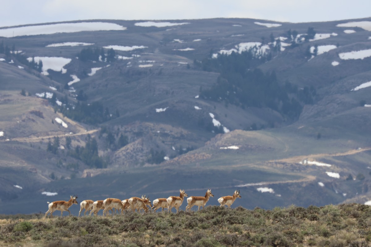
The pathway of a highly migratory western Wyoming pronghorn herd that’s been known by researchers for a quarter-century is at “high risk” of being lost.
That’s according to a draft “threat evaluation” released Thursday by the Wyoming Game and Fish Department in conjunction with an announcement that the state agency will consider identifying or designating migration corridors used by the Sublette Pronghorn Herd.
“In summary, the known current and potential threats pose a high risk to the functionality of the Sublette Pronghorn migration corridor,” the state’s evaluation reads. “The existing trend of suburban expansion and demand for renewable energy resources are the most concerning threats to the functionality of the corridor.”
The 13-page report includes a map, which shows three primary migration areas.
The largest, northmost part of the corridor connects Grand Teton National Park to the Green River Basin’s sagebrush sea. The southernmost migration area runs from the east slope of the Wyoming Range to the lowest reaches of the basin and the Interstate 80 corridor, while two other smaller routes branch off the southern Wind River Range and tread through the Red Desert.
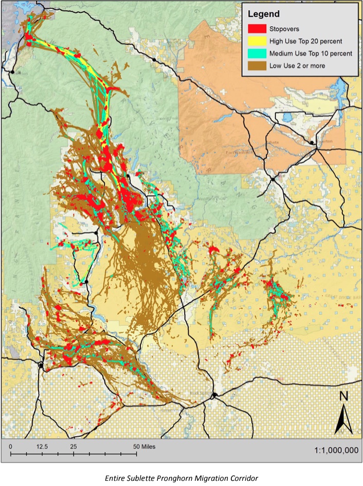
Scientists built the map off of the movements of 415 GPS-collared pronghorn that transmitted location data from 2002 to 2022. Biologists learned that roughly 75% of the Sublette Herd was migratory, and they traveled between 6 and 165 miles, according to the threat evaluation.
Also known as the ‘Path of the Pronghorn,’ management of the Sublette Pronghorn Herd’s migration has been scrutinized because of a politically influenced delay in recognizing the corridor. Game and Fish hit pause on classifying the Path of the Pronghorn, and subsequently, Gov. Mark Gordon rolled out an entirely new process for designating migration corridors.
Then the new policy went unused for over three years while a series of developments advanced within the likely corridor, including subdivisions, a 3,500-well gas field and a recent Wyoming gas auction that leased out 640 acres for $19 an acre within a bottleneck section that could soon be classified as “high use.”

Refining the scientific method for translating raw GPS collar data into a mapped corridor was a big reason for the delay, according to Game and Fish Deputy Chief Doug Brimeyer. Specifically, University of Wyoming researchers and others were developing a new “line buffer” method — and the final product was just published in the Journal of Applied Ecology
“We’re glad to see that the science has improved enough that we feel comfortable with what the line-buffer method has outlined as being the corridor,” Brimeyer said. “I think people might be questioning, ‘Well, if you had 20 years of data, why wouldn’t we have done something sooner?’ But I hope they can understand that when we used the [old method] it was a very, very large footprint.”
Professional conservationists who’ve engaged in Wyoming migration politics welcomed the state taking a step toward designating the Path of the Pronghorn.
“I feel really confident that Game and Fish is doing the right thing here,” said Meghan Riley, the public lands and wildlife advocate for the Wyoming Outdoor Council. “We’re really excited to support them and the animals.”

Nick Dobric, The Wilderness Society’s Wyoming conservation manager, pointed out how the state’s potential auction of the tract known as the “Kelly Parcel” is yet another potential incursion into the pronghorn’s migration path.
“Designating the Path of the Pronghorn and managing the state lands it crosses as vital habitats, and in cooperation with federal land management agencies, is exactly the kind of action needed if Wyoming officials want to lead the way in migration corridor conservation and ensure the future of our prized wildlife,” Dobric said in a statement.
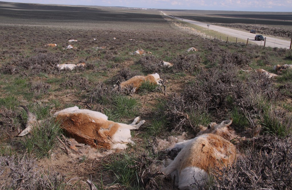
Game and Fish’s threat evaluation outlined other trends that don’t bode well for pronghorn. Sublette County’s human population grew 78% since 1990, adding barriers and stressors for the herd. Meanwhile, the herd just sustained its worst winter on record, a double whammy of weather and disease that left 75% of collared does dead by the spring thaw.
Industrial development from the oil and gas and renewable energy industries was yet another “significant” pressure identified.
“In the Pinedale Anticline Project Area adjacent to the Jonah Field, [Hall Sawyer] demonstrated that pronghorn both avoid energy infrastructure and spend considerably less time in traditional winter ranges once habitat fragmentation occurs due to development,” the document says. “More recently, solar energy developments have been constructed in the southern portion of the proposed corridor near Green River and along the Gateway West Transmission Line.”
Fencing at the solar developments creates a “complete movement barrier to migrating pronghorn,” the evaluation says.
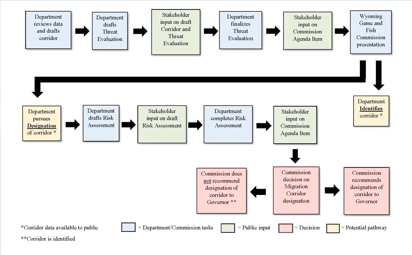
Although it’s officially begun, there’s a protracted process ahead to designate the Path of the Pronghorn. First, the state’s seeking public comment — remarks are due Jan. 5. There are also three upcoming public meetings: at 6 p.m. Nov. 16 in Pinedale, 6 p.m. Nov. 29 in Green River and 6 p.m. Nov. 30 in Jackson.
The plan is for the Wyoming Game and Fish Commission to consider moving forward with a designation at its March meeting, Brimeyer said. If the commission gives the agency the go-ahead, there are many steps after that. A more detailed “risk assessment” must be completed, and a stakeholder group will also be assembled to review the proposal. After that, the designation goes back to the Game and Fish Commission.
And that’s not the end of it. Ultimately, the decision to designate the Path of the Pronghorn will be made by Gordon. Depending on how long it all takes, it could even be his successor making the final call.
We should make sure the Pronghorn herd is able to migrate it’s instinctive route. Remove solar fencing, remove oil fields if they block migration. The animals were here first. Or build animal overpasses over the obstructions. We cannot continue to loose our wildlife. Thank you.
Alex iam positive and have proof as does Game and Fish that Antelope and the Grizzlies and Wolves do share same habitat atleast in this article “Path of the Pronghorn”. Pinedale ,Daniel, Granite Creek, Grays River all the way to Jackson Hole Airport they have been recorded.
Mr. Carter: The primary reason for Game and Fish acquiring solid, written easements across private land is their perpetual status as an “encumbrance” on the land all recorded in the court house – that is Register of Deeds. When Game and Fish makes a ‘recommendation” concerning migration corridors it carries virtually no legal standings. Same with land owners – usually ranchers – who enter into a formal conservation easement which restricts development long term. The Sublette county Commissioners may be pro-development but they are blocked by formal written conservation easements and/or migration easements. subdivisions and commercial/industrial development can be greatly restricted this way. However, it’s probably a first in time – first in right matter. I assume any new easements for migration corridors would be junior to any already existing easements and developments. Its my opinion that migration corridors across private land must be legally solid and this probably requires Game and Fish purchasing the easement from private land owners; that is, money must change hands – otherwise most landowners will be very reluctant to enter into a permanent encumbrance on their land which may diminish their property value. The easements of course, would not restrict grazing rights such that the land owners could continue their agricultural activities.
Yea forever for the antelope! Nea forever for big money!!!!
From the human population increase since 1990s was listed as an issue of antelope survival what are the poputation increase of Wolves and Grizzles impact to the antelope mortality since they were artifically increased ?
negligible/almost 0, since they dont share habitat.
The Green River Drift is part of the problem. Public lands ranching contributes almost nothing to the Wyoming economy and is detrimental to key areas of habitat for Wyoming wildlife. To protect our wildlife resources, antiquated ideas fostered through public lands ranching and exploitation of our public lands needs to end.
Yep, and unfortunately with its “historic trail” designation its now going to be even more difficult
The Sublette County Planning Department is revising the zoning regulations for Sublette County with the primary goal of development, short term rentals on every parcel and no attention to wildlife migration. The County Comprehensive Plan emphasizes wildlife, open space and rural values but is being ignored.
The County Board of Commissioners has shown little appetite for those values while approving large developments in the County, developments right in these critical wildlife habitats. Rich developers get their way, the public is ignored, while wildlife, peace and quiet are dismissed out of hand.
Wish AZ game a fish was as concerned about antelope migration corridors.
IT’S EASEMENT TIME!!!!
Wyoming Game and Fish needs to aggressively acquire migration easements across private land – particularly in the Green river drainage. the best available science has been generated and now is the time to put it to use. Wyoming has a long tradition of utilizing stock trails; and they can and have been recorded as formal easements in the various court houses in Wyoming – migration easements would be utilized exactly the same way. Once the migration easements are acquired, the County Commissioners/County Planners/Land Use Planning boards could require land use changes and subdivisions respect the easements; that is, they would actually be shown on subdivision plat maps along with road and utility easements.
But it doesn’t end there – how about Federal land. The current discussion about establishing conservation easements on Federal land might open the door for specific conservation easements across BLM and USFS lands specifically for migration corridors. Once established, future oil and gas leases would need to respect the migration corridors. The location of the corridors on Federal land would be dependent on the mapped corridors which Game and Fish has already generated.
And lastly, there would be a need for identifying migration corridors across State sections – again entirely based on Game and Fish’s recommendations.
Finally, the Green River drift route, needs to be formally protected by easements filed in the court houses when it crosses private land. With respect to Federal land, BLM RMPs and Forest Plans need to include the drift as an established Wyoming traditional – a cultural matter – which likewise needs consideration and included in the plans and management decisions.