
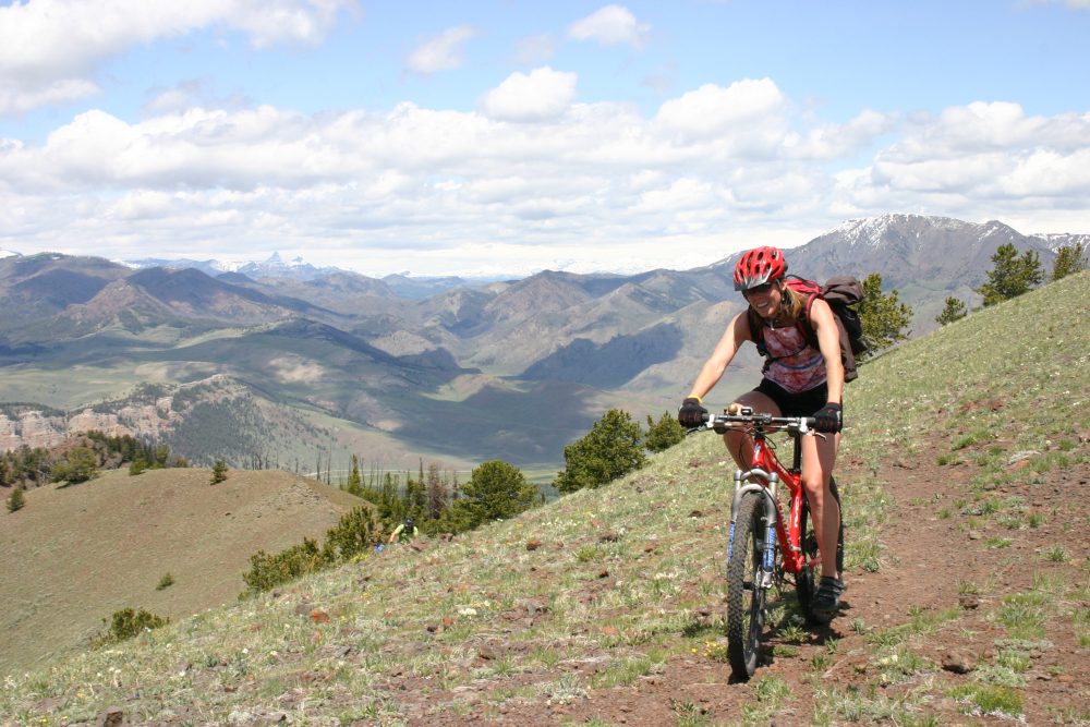
The Shoshone National Forest is planning on adding about 35 miles of new mountain bike trails, while also closing some unofficial paths people have been riding for years.
The agency seeks to accommodate a growing user group, with most of the new trails going into the Lander and Dubois areas, Shoshone National Forest spokeswoman Kristie Salzmann said.
The forest released a plan for its Mountain Bike Route Designation Project for public comment Nov. 30, and people can send the agency input through December.
The plan, which calls for 35 miles of new mountain bike trails, is an effort to fulfill a pledge to add more trails, said Salzmann.
The Forest Service made the commitment to mountain bikers when the agency decided in early 2015 to close the Dunoir Special Management Area to bikes. About 6.5 miles of a bike loop crossed through the special management area. That was a problem in managing the Dunoir area for wildlife and wilderness qualities. But closure of the loop meant riders lost a remote-feeling backcountry riding experience.
The new trails will serve that demand, Salzmann said. “The Shoshone as a whole is wild, all our trails outside of wilderness can give you that kind of experience,” she said.
Some of the 35 miles of new trails will be improvement on stock or unmaintained trails and some will be new development, she said.
The majority of the proposed new trails are in the Lander and Dubois areas. In Cody, fewer people bike on forest service land and there is a very nice network of nearby trails on Bureau of Land Management Land, Salzmann said.
John Gallagher, president of the Park County Pedalers, isn’t worried that new trails aren’t planned for Cody.
He is, however, worried about the Shoshone’s plans to close popular trails in the Sunlight Basin as part of its plan for mountain biking.
The Forest Service’s project calls for closing rides that aren’t part of the official trail system, Salzmann said, adding that other forests have issues with cross-country travel on mountain bikes off system trails. On the Shoshone, closing unofficial trails is a pre-emptive measure to make sure biking is limited to trails the forest officially recognizes as part of its system.
Gallagher says his group is not happy. The proposed closures are unexpected and will “change the whole user experience drastically,” he said.

riders worry they’ll lose access to if the Forest Service limits riding only to trails officially
recognized by the agency. (John Gallagher, Park County Pedalers)
“There is definitely going to be a loss of trail and I’m sure the loss will be superior to anything we gain,” Gallagher said.
It also will be hard to know what trails are legal. There isn’t an easy-to-access database online and many trails in the forest are not marked, Gallagher noted.
Tim Young, executive director of Wyoming Pathways, agrees. Wyoming Pathways is an organization that advocates for better bicycle and walking paths in public right-of ways, and improved recreational opportunities for mountain biking, hiking, running and cross-country skiing on public lands.
Shoshone Forest hasn’t kept accurate maps and it’s hard to find information on what is officially a trail, according to Young. Many users don’t realize their favorite trails aren’t part of the official system. People might suddenly find themselves ticketed for riding something they’ve ridden for 20 years, Young said.
Young is disappointed in how mountain biking has been treated by the Forest Service. After bikes were banned in the Dunoir in 2015 when the Shoshone finalized its resource management plan, the agency started in on a separate travel management plan. But only motorized recreation was studied under that plan, Young said. The agency needs to spend more time understanding what trails exist on the Shoshone, he said.
But the Shoshone plan is not all bad news, especially near Lander, said an area rider. A proposed five-mile trail will create a 22-mile loop taking riders from the Nature Trail in Sinks Canyon State Park up the Brewer’s Trail to Fossil Hill, then down the Sheep Bridge Trail to the Middle Fork Trail and back to the start, said Tony Ferlisi, the USFS Trails Issues Advocate with Lander Cycling.
“It’s going to be a sweet loop on single track,” he said. It will also likely become the area’s flagship trail.
The Lander area also has several unofficial trails, like the Blue Ridge Trail off the Loop Road, that are currently ridden regularly, but could close. The plan calls for all unofficial trails to close. Ferlisi said he is talking with the Forest Service about these trails, hoping they might be added to the official trail network and kept open.
“The whole idea of losing legal access to something we use is a big deal,” he said.
Ferlisi said the Forest Service has been receptive to feedback.
“They are recognizing pretty quickly that there is a user group here that is growing whose voices are becoming a little bit more (loud),” he said. “We want them to get a landscape perspective of what is actually going on—what trails people are actually riding, what are our needs and what do we want?”
Salzmann, the forest service spokeswoman, said the commenting period is the perfect time for people to talk about what trails aren’t part of the system.
Stay connected — sign up for WyoFile’s free weekly newsletter
“We can’t be everywhere on the forest, so if there is a great trail someone is passionate about, this is their time to provide input so we can look at where it is and see if it’s feasible to add it,” she said.
No matter what happens, Young said the new trails don’t replace the wild experience of riding in the Dunoir.
Ferlisi agrees, but also thinks the outcry over the loss of the Dunoir “was a wake-up call more than anything else, to both the Forest Service and mountain bikers,” he said. “I think this is the best case scenario based on that decision.”
Look, I don’t begrudge any backcountry user. You want to access on your two feet (my typical method) great, have a horse good for you, mountain bike well just be alert and don’t run me over and great. There are studies that show biking impacts are closer/equivalent to hiking which is less than llamas which in turn is less than equestrian. There is a good article on americantrails(dot)org about it. Not sure if wyofile allows hyperlinking, but it is easy to google and find. So for those insinuating above that equestrian use is less disruptive to the backcountry, that just isn’t supported by the studies. By the way up north in Canada they have bike trails through dense grizzly country as well, and I am not aware of any studies showing higher rates of bear-biker interaction than bear-hiker or bear-equestrian interaction rates. While I personally wouldn’t want to be tearing through griz country on a bike, neither would I want to be on a horse.
I just find it hypocritical those who access the forest on trails in the most disruptive manner (equestrian) ragging on other users who access the forest in a less disruptive manner. My two cents.
I strongly supported the decision to close the Dunoir SMU to bikes, simply because the Kissinger Lakes trail is in prime grizzly habitat. Some biking advocates seem to feel that their DESIRE for more trails in wild areas should take precedence over the NEED for grizzlies to survive in those areas. I’m grateful for the respect and restraint that biking advocates like Tony Ferlisi and Forrest McCarthy have shown throughout this process; they appear to be in a tiny minority of bikers who understand that bikes are simply inappropriate in certain areas with exemplary wilderness values. In the current political climate, especially with the WPLI process that’s front-loading multiple use in all WSA’s now underway, and with Cathy McMorris Rodgers about to take over the Interior Department, wilderness advocates and grizzlies stand to lose far, far more than trail miles for bikers.
Benji Sinclair
Jackson, WY
Correction: Mountain bikers did not “lose” the so-called Dunoir mountain bike trail. They had stolen it and we took it back.
In other words, mountain bikers illegally built the trail. In addition to breaking the law repeatedly, they did considerable ecological damage and created a public safety hazard for hikers and equestrians.
Local conservationists complained for years about the illegal trail but the Shoshone National Forest prevaricated, lied, and let the trail remain open. Finally, at the end of the Forest planning process, we provided the Shoshone National Forest with ample and unimpeachable arguments based in law as to the trail’s illegality.
(See for example my legal analysis at http://www.fs.usda.gov/Internet/FSE_DOCUMENTS/stelprd3796025.pdf).
The Forest, to avoid the embarrassment of losing a lawsuit over the issue, had to agree–grudgingly–to close the trail.
So now it appears the Shoshone is trying to pacify loud mountain bikers with some legal trails so that they can have “experiences.” I guess that’s preferable to letting them get away with illegal trails.
Just watch out for the grizzly bears.
Nice job covering what is a complex situation. I would to offer some clarification. The closure of the Dunoir to mountain bikes resulted in a loss of 28.4 miles of trail, not the 6.5 mile number we keep hearing from the SNF. Specifically, if you look at the draft record of decision for the Land Management Plan:
“In considering the public comment for mountain bike use in the area I have decided to permit continued use of mountain bikes on 6.8 miles of the Pinnacle Trail within the Dunoir SMU. Mountain bike use is prohibited on the remaining 21.6 miles of trail in the Dunoir SMU…” That is a total of 28.4 miles of lost trail.
The final ROD resulted in a reversal on mountain bikes and included the following language on page 16: “Although bicycle use will be prohibited in the Dunoir Special Management Unit, I am directing the Forest Supervisor to analyze alternative opportunities for user groups directly affected by this decision during the upcoming travel management planning effort.”
To this day, you still cannot download a database or map of current system trails on any USFS web site. This makes it very difficult to comment. The Notice of Proposed Action document can be accessed on the Web at http://www.fs.usda.gov/project/?project=50621&exp=overview or contact Olga Troxel at 307-527-6921 between 8:00 AM and 4:30 PM on weekdays or via email at otroxel@fs.fed.us for further information or to request a copy of the Proposed Action that provides specific details regarding the project.
Failure to provide public access to a map or database of the current system trails should be a trigger for an extension of the public comment process until such information can be made available. And how did they conduct a proper public scoping without that information? I supported the decision on Dunoir SMA but the non-motorized-MTB folks are getting hosed by the SNF on the pending travel plan without good data.