

“Wild Migrations, Atlas of Wyoming’s Ungulates,” published last month, presents 70 compelling migration stories from one of the most studied ecosystems on earth and offers a first-of-its-kind resource for wildlife advocates and managers.
The long-awaited oversize, full-color book reveals the state’s migratory wildlife fabric through innovative maps, graphs, charts, illustrations and photographs. In 208 elegant pages, readers can see the web wildlife weave as a million animals traverse the state on their mandatory but perilous journeys, frequently made more difficult by humans.
A collaboration among scientists, map-makers, photographers and authors, “Wild Migrations” presents the information that could make a roadmap for Equality State ungulate conservation easy to draw. The publication stops shy of plotting that course, however. It presents the science, not the solution, leaving application of its lessons to others.
“To date no ungulate migration [route] in Wyoming is fully protected from end to end,” said Gregory Nickerson, a writer with the Wyoming Migration Initiative at the University of Wyoming (and a former WyoFile reporter). He spoke along with several of the book’s six authors on a recent promotional tour.
The scientists, Nickerson said, hope “to do something other than let these migrations blink out.” But their job in many instances is to study, not to dictate, legislate or regulate, and “not to describe how conservation should happen,” he said.
Decision-makers have a full toolbox, said Matthew Kauffman, University of Wyoming associate professor, co-founder of the initiative and lead author of “Wild Migrations.” Pointing to the Yellowstone ecosystem, he said, there’s “more information on migration in the area than any other on the planet.”
The glossy book makes some policy opportunities apparent. “We could do a better job of conserving,” said Doug McWhirter, wildlife management coordinator with Wyoming Game and Fish Department for the Jackson and Pinedale regions.
Such conservation is critical if Wyoming seeks to preserve its heritage, said Fred Lindzey, a former leader at the Wyoming Cooperative Fish and Wildlife Research Unit at UW and former president of the Wyoming Game and Fish Commission.
If there’s anything we should have learned, he said in a telephone interview, it’s that it’s much easier to protect habitat than to reconstruct it. “I think the same thing goes with migration corridors,” he said.
A new understanding
Migrations are as varied as the animals that make them, “Wild Migrations” reveals. The stereotype of the lead cow elk one day deciding — because of the arc of the sun, the temperature or the depth of snow — that it’s time to take the herd home is just that, a stereotype. But migrations have a common thread — animals’ fidelity to route and range.
McWhirter pointed to moose in Buffalo Valley in north Jackson Hole as an example. In the spring, the handful of gangly legged ungulates take off for their summer ranges, but at widely different times. The first moose leaves the valley floor in May, but the last doesn’t go until July.

The May departure coincides with the time that moose’s traditional and revisited summer range greens up. The moose that leaves in July is headed farther north and higher in elevation — into southern Yellowstone National Park. This also indicates “some understanding of when things green up,” McWhirter said. It even illustrates the transfer of that learned behavior to a new generation.
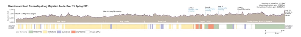
In other instances, elk and deer “surf the green wave,” McWhirter and others say. As plants mature, their nutritional value declines and portions of roughage increases to the disadvantage of wildlife. As animals move along their spring migration routes changing elevation and latitude they exploit the most nutritious stage of their forage’s development. For Red Desert deer, the seasonal route is less of a highway and more of a Safeway. Migration routes are habitat, scientists say.
That perspective represents a significant shift for wildlife managers who have long emphasized protecting other known seasonal habitat areas, such as winter ranges or parturition areas.
Radio collaring technology, which can now pinpoint an animal every few hours, reveals that migrating deer don’t travel as though they’re on a forced march, as was once believed. They leverage what are known as stopover areas to rest and replenish.
Those areas are critical, said Scott Smith, deputy director at the Wyoming Game and Fish Department. “Through [biologist] Hall Sawyer’s research, he’s determined that 95 percent of the time the mule deer spends during the migration is spent foraging and resting in these stopover areas.”
Migration as policy
The appointed civilian Wyoming Game and Fish Commission in 2016 agreed that migration routes, bottlenecks and stopover areas are “vital habitat” and amended its policies to list them as such. “No other state, McWhirter said, “has formally elevated migration to such a level.”
The policy calls for “no significant declines in species distribution, abundance or loss of habitat function,” Smith said. The policy gives the department authority to designate corridors without having to seek additional commission approval.
“We’ll initiate these [research] projects,” Smith said, with local biologists and wardens asking simple questions about what their herds might be up to. “That’s kind of the jumping-off point,” for identifying migration corridors he said. “It’s not just someone goes out and decides ‘Today I’m going to go out and collar whatever species and determine migration routes across the landscape.’”
The Game and Fish Department, however, doesn’t have an internal research arm. Instead the agency relies on research partners such as Sawyer and his employer, the consulting firm WEST; Arthur Middleton of the University of California, Berkeley; and Kauffman’s UW Co-op, which includes biologist Kevin Monteith and many others. (See the WyoFile video “When Mule Deer Fly” about a capture operation.)
“Wild Migrations” explains how migration routes were studied and the role of evolving technology in identifying stopover areas and bottlenecks. The Path of the Pronghorn, for example, the only federally recognized migration route in the country, was discovered beginning in 1985 when biologists trapped several pronghorn in the southern Green River Basin and fitted them with colored, vinyl neckbands — no beacons or transmitters. “The next summer, two adult female pronghorn wearing white neckbands were observed in Jackson Hole, indisputably linking the valley to the winter range, 150 miles to the south,” the atlas reads.
Telemetry came in 1998, with UW biologists, including Sawyer, tracking pronghorn collared with VHF transmitters. Sawyer and others located animals’ positions with hand-held receivers and produced what was essentially a line through the Gros Ventre Mountains from the Snake River to Green River drainages.
Grand Teton National Park biologists, including Steve Cain, came next with GPS collars that provided a polygon of the path. The waypoints added dimension to Sawyer’s lines, revealing the width and time of use to the travel route.
Armed with that information, the Bridger-Teton National Forest amended its management plan to largely preclude human interference in the path.
For Game and Fish, such information collected elsewhere is relayed to field managers who meet with stakeholders. Eventually a migration route might be identified and adopted, with ultimate approval resting with the agency wildlife coordinator in Cheyenne.
To date, Game and Fish has designated the Red Desert to Hoback mule deer migration corridor along with ones near Baggs and in the Platte River drainage. Designation of a corridor brings a host of preservation strategies, from how to protect animals from speeding vehicles to reducing exotic invasive weeds like cheetgrass.
Is it enough?
Thirty years after white-collared pronghorn does showed up in Jackson Hole after trekking 150 miles from the south, Game and Fish still hasn’t designated a corridor for those animals. Meantime, the Bureau of Land Management has approved gas field development, including the Normally Pressured Lance Field that lies astride the route in southern Sublette County.
Game and Fish designation could have given the federal agency more leverage to call for limits when approving the field earlier this summer. “We’re still evaluating the Sublette antelope data set,” Smith, with the agency, said. “That’s ongoing. The Path of the Pronghorn is a portion of that.”

Threats continue to dog Wyoming’s migration routes, according to the atlas and advocates concerned by increased oil and gas leasing. For leases proposed near or in the Hoback mule deer corridor, “we have to look at every single parcel as it’s nominated and evaluate each to see its juxtaposition to the designated corridor,” Smith said.
In a letter sent in September to the BLM, Game and Fish recommended some parcels proposed for lease sale in December not be immediately auctioned and that others include a “lease notice,” asking developers to work with the agency to reduce impact on the migration route.
If as much as 90 percent of a parcel lies inside the corridor, “they could build their infrastructure outside [on the 10 percent] and directionally drill, still providing them an opportunity to extract their resource and not impact the corridor,” Smith said.
If the parties cannot come to an agreement where to site the infrastructure, “then the BLM cannot come up with a finding of no significant impact,” he said. “That would trigger a new [environmental review] process. The BLM would have to reanalyze that parcel over again.”
Critics of that approach, including the Wyoming Outdoor Council, argue the “notices” are toothless. They see a potential erosion of habitat. Seventeen parcels, approximately 31,470 acres proposed for sale, lie in the mule deer corridor, WOC said in a letter to the BLM. Others leases are in big game crucial winter ranges, the conservation group said. The agency’s shoddy, incomplete analysis would make some lease sales a violation of federal environmental laws, WOC wrote the BLM in a letter endorsed by the National Audubon Society, The Wilderness Society and the Wyoming Wilderness Association.
“The underlying [resource management plans] offer no
analysis of impacts to migration corridors, because they were issued before those corridors were identified,” the groups wrote. “Loss of migration will result in a marked decrease in the knowledge ungulates possess about how to optimally exploit their habitats.”
A new way of showing science
An eight-day, 80-mile solo hike by Emilene Ostlind resulted in a prizewinning 2011 story in High Country News about the Path of the Pronghorn that opened many eyes. With photographer Joe Riis, the two told a scientific story in an accessible format that reached thousands of readers and elevated the long migration in the public hemisphere.
“We saw from Joe’s photos of the Path of the Pronghorn and the attention he and Emilene got with that High Country News article that combining photos with stories could reach a larger audience,” Sawyer said. Consequently, when a bunch of collared mule deer he thought might meander over the next hill didn’t stop for 150 miles, Sawyer thought the Red Desert to Hoback migration could be similarly promoted.
“It quickly became apparent,” however, “photos were not working well for mule deer,” Sawyer said. “The pictures alone were not conveying that sense of movement. We needed video.”

So Riis learned a new craft with his camera traps and, with the help of the Cornell Lab of Ornithology (which happened to be filming sage grouse in the area at the time) produced a short film.
Today the video has had, “you could safely say, seven million views,” Sawyer said.
Researchers coupled the video with a glossy booklet detailing the corridor with maps and photographs and descriptions of challenges facing the deer. They went on the road with slideshow presentations and a photography exhibit. The initiative was a different approach from writing a journal paper in stiff, scientific language with inaccessible graphs and tables.
Among the revelations, the deer crossed property owned by 41 different private parties. One, bisecting the corridor at a critical bottleneck at the outlet of Fremont Lake, was on the market for development as a subdivision.
“Armed with a map, the late Luke Lynch worked tirelessly [with the Conservation Fund] to raise money and acquire that parcel,” Sawyer said. Lynch died in 2015 as the result of an avalanche while climbing Mount Moran on a ski expedition. The once-vulnerable parcel now bears his name.
The preservation, Sawyer said, reveals “the power of maps.” All of that previous work “snowballed” into the atlas, he said. In “Wild Migrations,” the talents of University of Oregon cartographer Jim Meacham blossom and the color plates overflow with information.
They don’t reveal all, however.
“There’s a lot of things we don’t know about why certain paths are chosen,” Lindzey said. If preserving them means forgoing a gas lease here, a well pad or building site there, however, “that’s a small price to pay,” he said.
Become a supporting member today and your donation will be matched
With the atlas, Wyoming residents have their marching orders for conservation. “We don’t know where the tipping point is,” McWhirter said of corridors that may be nickeled and dimed to death with generations of migratory memory lost. For writer Annie Proulx, who penned the forward to the atlas, it may hover anywhere, possibly very close.
“Movement ecology,” she wrote, “presents existence as quivering with the perpetual motion of shifting rivers; toppling forests and swaying kelp beds; migrating birds, insects, fishes, amphibians, mammals; flying, diving, spinning, burying, burrowing life intricately making up the whole web of existence. Disturb one thread and a shiver surges through the entire corpus.”
This story was corrected Nov. 13 to reflect the correct time the Game and Fish letter was sent to the BLM — Ed.
Since the Petroleum Club closed down in Casper , how are we going to get the members of the Wyoming Oil and Gas Commission to study this fabulous migration atlas and pass a pop test on its verity , so we the people not beholden to hydrocarbons know that they know ? Ditto the Legislature ? Wyoming DEQ ? State Land Board ? The troika of Barrasso-Enzi-Mrs. Elizabeth perry ? ( I have no idea how to approach the Federal overseers and regulators , especially the robber barons that Trump has inflicted upon us )
It is well past the time that Wyoming admit it’s addicted to energy and mineral money and has been giving the Hydrocarbon Hegemony almost everything it ever asked for, even allowing them to craft legislation favoring their stockholders over Wyoming residents. We need to wean ourselves from mineral money dependence at the State level . It won’t be easy , but it’s necessary.
Demonstrating a working awareness of wildlife migration in the larger context of habitat sustainability is a big step. But what needs to really be communicated to the extractors is Wyoming folks love their wildlife and they really would like to keep them around… quarterly sales figures and annual reports seldom reflect the proviso required to sustain other large mammals besides those corporate peeps.
For starters, trophy hunting is Not a viable wildlife management tool. Secondly, drill in your backyard and see how much rest or feeding actually done. Poisoned air, water, and soil only sicken the life, All life. A serious choice needs to be made, either to truly love the planet and helping all on her to survive or continuing as we have allowing some men to get scary rich while the rest dies. I’m willing to bet we continue as is killing off the best genes for building a healthy population, cwd for example, and frack baby frack. Money will always take precedence over life, any life.